|
|
|||||||||||||||||
| Point ID: 786 | Downloads | Plots | Site Data | Code: 07HD001 |
|
|
|||||||||||||||||
| Download | |
|---|---|
| Site Descriptor Information | Site Time Series Data |
| Link to all available data | |
|
|
| View: | Statistics | Time Series |
| Units: | mm |
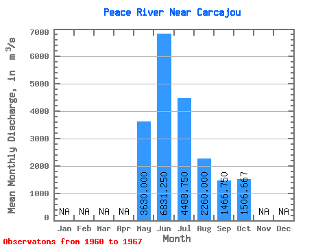
| Statistic | Jan | Feb | Mar | Apr | May | Jun | Jul | Aug | Sep | Oct | Nov | Dec | Annual |
|---|---|---|---|---|---|---|---|---|---|---|---|---|---|
| Mean | 3630.00 | 6831.25 | 4488.75 | 2260.00 | 1466.75 | 1506.67 | |||||||
| Standard Deviation | 355.11 | 1508.31 | 1245.82 | 1181.45 | 354.44 | 225.54 | |||||||
| Min | 3270.00 | 5490.00 | 2600.00 | 1030.00 | 944.00 | 1360.00 | |||||||
| Max | 3980.00 | 9530.00 | 6140.00 | 4870.00 | 1960.00 | 1960.00 | |||||||
| Coefficient of Variation | 0.10 | 0.22 | 0.28 | 0.52 | 0.24 | 0.15 |
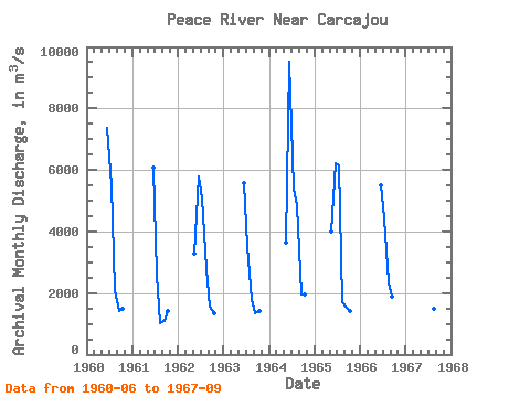
| Year | Jan | Feb | Mar | Apr | May | Jun | Jul | Aug | Sep | Oct | Nov | Dec | Annual | 1960 | 7360.00 | 5500.00 | 2080.00 | 1430.00 | 1480.00 | 1961 | 6090.00 | 2600.00 | 1030.00 | 1080.00 | 1430.00 | 1962 | 3270.00 | 5800.00 | 5060.00 | 2780.00 | 1560.00 | 1360.00 | 1963 | 5580.00 | 3530.00 | 1790.00 | 1330.00 | 1410.00 | 1964 | 3640.00 | 9530.00 | 5390.00 | 4870.00 | 1960.00 | 1960.00 | 1965 | 3980.00 | 6230.00 | 6140.00 | 1720.00 | 1540.00 | 1400.00 | 1966 | 5490.00 | 4420.00 | 2340.00 | 1890.00 | 1967 | 8570.00 | 3270.00 | 1470.00 | 944.00 |
|---|
 Return to R-Arctic Net Home Page