|
|
|||||||||||||||||
| Point ID: 786 | Downloads | Plots | Site Data | Code: 07HD001 |
|
|
|||||||||||||||||
| Download | |
|---|---|
| Site Descriptor Information | Site Time Series Data |
| Link to all available data | |
|
|
| View: | Statistics | Time Series |
| Units: | m3/s |
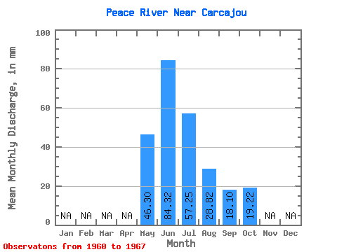
| Statistic | Jan | Feb | Mar | Apr | May | Jun | Jul | Aug | Sep | Oct | Nov | Dec | Annual |
|---|---|---|---|---|---|---|---|---|---|---|---|---|---|
| Mean | 46.29 | 84.32 | 57.24 | 28.82 | 18.10 | 19.21 | |||||||
| Standard Deviation | 4.53 | 18.62 | 15.89 | 15.07 | 4.38 | 2.88 | |||||||
| Min | 41.70 | 67.76 | 33.16 | 13.13 | 11.65 | 17.34 | |||||||
| Max | 50.75 | 117.63 | 78.30 | 62.10 | 24.19 | 25.00 | |||||||
| Coefficient of Variation | 0.10 | 0.22 | 0.28 | 0.52 | 0.24 | 0.15 |
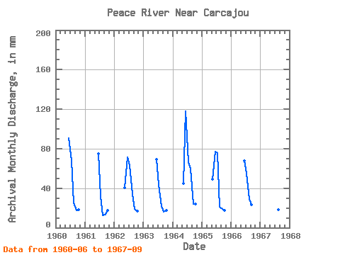
| Year | Jan | Feb | Mar | Apr | May | Jun | Jul | Aug | Sep | Oct | Nov | Dec | Annual | 1960 | 90.84 | 70.14 | 26.52 | 17.65 | 18.87 | 1961 | 75.17 | 33.16 | 13.13 | 13.33 | 18.24 | 1962 | 41.70 | 71.59 | 64.53 | 35.45 | 19.25 | 17.34 | 1963 | 68.87 | 45.02 | 22.83 | 16.42 | 17.98 | 1964 | 46.42 | 117.63 | 68.73 | 62.10 | 24.19 | 25.00 | 1965 | 50.75 | 76.90 | 78.30 | 21.93 | 19.01 | 17.85 | 1966 | 67.76 | 56.37 | 29.84 | 23.33 | 1967 | 105.78 | 41.70 | 18.75 | 11.65 |
|---|
 Return to R-Arctic Net Home Page