|
|
|||||||||||||||||
| Point ID: 7828 | Downloads | Plots | Site Data | Code: 3194 |
|
|
|||||||||||||||||
| Download | |
|---|---|
| Site Descriptor Information | Site Time Series Data |
| Link to all available data | |
|
|
| View: | Statistics | Time Series |
| Units: | mm |
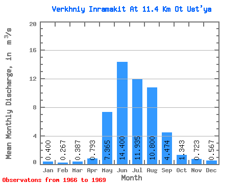
| Statistic | Jan | Feb | Mar | Apr | May | Jun | Jul | Aug | Sep | Oct | Nov | Dec | Annual |
|---|---|---|---|---|---|---|---|---|---|---|---|---|---|
| Mean | 0.40 | 0.27 | 0.39 | 0.79 | 7.37 | 14.40 | 11.94 | 10.80 | 4.47 | 1.34 | 0.72 | 0.57 | 4.59 |
| Standard Deviation | 0.04 | 0.08 | 0.18 | 0.23 | 2.30 | 6.08 | 5.33 | 3.38 | 0.86 | 0.15 | 0.05 | 0.13 | 0.30 |
| Min | 0.36 | 0.18 | 0.22 | 0.53 | 5.74 | 10.10 | 8.17 | 6.90 | 3.68 | 1.17 | 0.69 | 0.47 | 4.38 |
| Max | 0.44 | 0.33 | 0.57 | 0.98 | 8.99 | 18.70 | 15.70 | 12.80 | 5.38 | 1.45 | 0.78 | 0.72 | 4.81 |
| Coefficient of Variation | 0.10 | 0.29 | 0.45 | 0.30 | 0.31 | 0.42 | 0.45 | 0.31 | 0.19 | 0.11 | 0.07 | 0.24 | 0.07 |
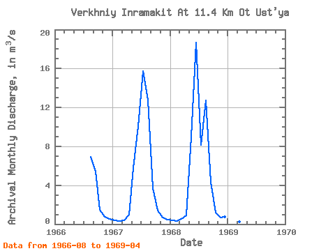
| Year | Jan | Feb | Mar | Apr | May | Jun | Jul | Aug | Sep | Oct | Nov | Dec | Annual | 1966 | 6.90 | 5.38 | 1.45 | 0.78 | 0.51 | 1967 | 0.36 | 0.29 | 0.37 | 0.98 | 5.74 | 10.10 | 15.70 | 12.80 | 3.68 | 1.41 | 0.69 | 0.47 | 4.38 | 1968 | 0.40 | 0.33 | 0.57 | 0.87 | 8.99 | 18.70 | 8.17 | 12.70 | 4.36 | 1.17 | 0.70 | 0.72 | 4.81 | 1969 | 0.44 | 0.18 | 0.22 | 0.53 |
|---|
 Return to R-Arctic Net Home Page