|
|
|||||||||||||||||
| Point ID: 7828 | Downloads | Plots | Site Data | Code: 3194 |
|
|
|||||||||||||||||
| Download | |
|---|---|
| Site Descriptor Information | Site Time Series Data |
| Link to all available data | |
|
|
| View: | Statistics | Time Series |
| Units: | m3/s |
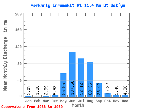
| Statistic | Jan | Feb | Mar | Apr | May | Jun | Jul | Aug | Sep | Oct | Nov | Dec | Annual |
|---|---|---|---|---|---|---|---|---|---|---|---|---|---|
| Mean | 3.09 | 1.88 | 2.98 | 5.93 | 56.84 | 107.56 | 92.11 | 83.35 | 33.42 | 10.37 | 5.40 | 4.37 | 417.88 |
| Standard Deviation | 0.31 | 0.55 | 1.35 | 1.75 | 17.74 | 45.42 | 41.09 | 26.07 | 6.39 | 1.17 | 0.37 | 1.04 | 27.28 |
| Min | 2.78 | 1.27 | 1.70 | 3.96 | 44.30 | 75.44 | 63.05 | 53.25 | 27.49 | 9.03 | 5.15 | 3.63 | 398.59 |
| Max | 3.40 | 2.32 | 4.40 | 7.32 | 69.38 | 139.68 | 121.17 | 98.78 | 40.19 | 11.19 | 5.83 | 5.56 | 437.17 |
| Coefficient of Variation | 0.10 | 0.29 | 0.45 | 0.30 | 0.31 | 0.42 | 0.45 | 0.31 | 0.19 | 0.11 | 0.07 | 0.24 | 0.07 |
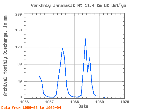
| Year | Jan | Feb | Mar | Apr | May | Jun | Jul | Aug | Sep | Oct | Nov | Dec | Annual | 1966 | 53.25 | 40.19 | 11.19 | 5.83 | 3.94 | 1967 | 2.78 | 2.04 | 2.86 | 7.32 | 44.30 | 75.44 | 121.17 | 98.78 | 27.49 | 10.88 | 5.15 | 3.63 | 398.59 | 1968 | 3.09 | 2.32 | 4.40 | 6.50 | 69.38 | 139.68 | 63.05 | 98.01 | 32.57 | 9.03 | 5.23 | 5.56 | 437.17 | 1969 | 3.40 | 1.27 | 1.70 | 3.96 |
|---|
 Return to R-Arctic Net Home Page