|
|
|||||||||||||||||
| Point ID: 7816 | Downloads | Plots | Site Data | Code: 3146 |
|
|
|||||||||||||||||
| Download | |
|---|---|
| Site Descriptor Information | Site Time Series Data |
| Link to all available data | |
|
|
| View: | Statistics | Time Series |
| Units: | mm |
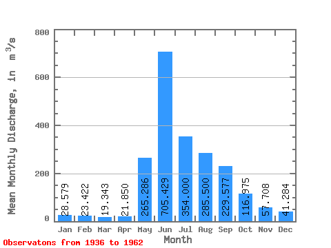
| Statistic | Jan | Feb | Mar | Apr | May | Jun | Jul | Aug | Sep | Oct | Nov | Dec | Annual |
|---|---|---|---|---|---|---|---|---|---|---|---|---|---|
| Mean | 28.58 | 23.42 | 19.34 | 21.85 | 265.29 | 705.43 | 354.00 | 285.50 | 229.58 | 116.97 | 57.71 | 41.28 | 175.10 |
| Standard Deviation | 5.21 | 3.70 | 4.00 | 3.67 | 83.10 | 129.45 | 111.56 | 96.26 | 102.32 | 28.27 | 11.77 | 10.61 | 25.43 |
| Min | 15.50 | 15.50 | 14.60 | 16.90 | 135.00 | 546.00 | 166.00 | 123.00 | 99.50 | 60.50 | 40.00 | 26.00 | 122.69 |
| Max | 33.40 | 29.00 | 27.00 | 30.80 | 395.00 | 928.00 | 522.00 | 524.00 | 540.00 | 170.00 | 81.00 | 59.00 | 208.44 |
| Coefficient of Variation | 0.18 | 0.16 | 0.21 | 0.17 | 0.31 | 0.18 | 0.32 | 0.34 | 0.45 | 0.24 | 0.20 | 0.26 | 0.14 |
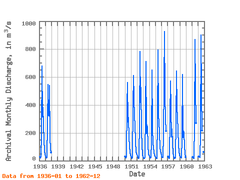
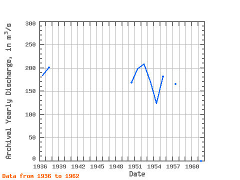
| Year | Jan | Feb | Mar | Apr | May | Jun | Jul | Aug | Sep | Oct | Nov | Dec | Annual | 1936 | 31.00 | 25.00 | 20.00 | 27.00 | 192.00 | 680.00 | 314.00 | 383.00 | 254.00 | 156.00 | 66.00 | 46.00 | 182.83 | 1937 | 33.00 | 25.00 | 18.00 | 23.00 | 269.00 | 546.00 | 325.00 | 321.00 | 540.00 | 170.00 | 81.00 | 59.00 | 200.83 | 1950 | 32.00 | 28.00 | 21.00 | 30.80 | 395.00 | 562.00 | 278.00 | 310.00 | 162.00 | 105.00 | 56.00 | 40.00 | 168.32 | 1951 | 30.00 | 24.00 | 14.80 | 21.80 | 388.00 | 612.00 | 458.00 | 307.00 | 264.00 | 137.00 | 60.50 | 51.00 | 197.34 | 1952 | 33.40 | 21.00 | 16.10 | 20.80 | 292.00 | 784.00 | 419.00 | 524.00 | 207.00 | 118.00 | 40.00 | 26.00 | 208.44 | 1953 | 19.80 | 17.60 | 15.20 | 22.00 | 356.00 | 712.00 | 196.00 | 257.00 | 234.00 | 113.00 | 45.20 | 39.20 | 168.92 | 1954 | 29.80 | 23.50 | 21.20 | 22.30 | 135.00 | 651.00 | 234.00 | 123.00 | 99.50 | 60.50 | 42.70 | 29.80 | 122.69 | 1955 | 26.00 | 22.80 | 14.60 | 16.90 | 282.00 | 795.00 | 317.00 | 286.00 | 193.00 | 98.20 | 64.80 | 55.90 | 181.02 | 1956 | 32.40 | 24.20 | 22.50 | 21.70 | 182.00 | 928.00 | 473.00 | 302.00 | 214.00 | 1957 | 31.10 | 22.00 | 17.90 | 21.00 | 318.00 | 570.00 | 382.00 | 170.00 | 226.00 | 122.00 | 55.50 | 39.00 | 164.54 | 1958 | 15.50 | 15.50 | 24.00 | 18.90 | 286.00 | 645.00 | 382.00 | 313.00 | 215.00 | 114.00 | 67.60 | 43.00 | 178.29 | 1959 | 29.10 | 27.30 | 23.50 | 19.40 | 160.00 | 618.00 | 166.00 | 213.00 | 198.00 | 101.00 | 51.60 | 26.70 | 136.13 | 1961 | 26.00 | 23.00 | 15.00 | 17.00 | 265.00 | 870.00 | 522.00 | 271.00 | 1962 | 31.00 | 29.00 | 27.00 | 23.30 | 194.00 | 903.00 | 490.00 | 217.00 | 178.00 | 109.00 | 61.60 | 39.80 | 191.89 |
|---|
 Return to R-Arctic Net Home Page