|
|
|||||||||||||||||
| Point ID: 7816 | Downloads | Plots | Site Data | Code: 3146 |
|
|
|||||||||||||||||
| Download | |
|---|---|
| Site Descriptor Information | Site Time Series Data |
| Link to all available data | |
| View: | Time Series | All |
| Units: | mm |
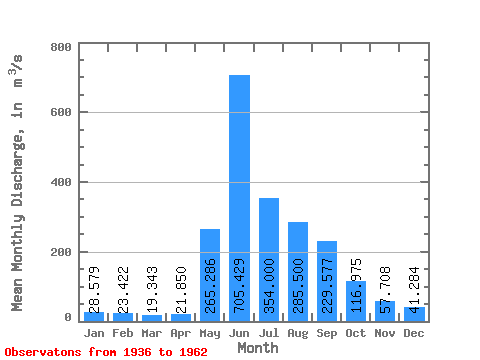
| Statistic | Jan | Feb | Mar | Apr | May | Jun | Jul | Aug | Sep | Oct | Nov | Dec | Annual |
|---|---|---|---|---|---|---|---|---|---|---|---|---|---|
| Mean | 28.58 | 23.42 | 19.34 | 21.85 | 265.29 | 705.43 | 354.00 | 285.50 | 229.58 | 116.97 | 57.71 | 41.28 | 175.10 |
| Standard Deviation | 5.21 | 3.70 | 4.00 | 3.67 | 83.10 | 129.45 | 111.56 | 96.26 | 102.32 | 28.27 | 11.77 | 10.61 | 25.43 |
| Min | 15.50 | 15.50 | 14.60 | 16.90 | 135.00 | 546.00 | 166.00 | 123.00 | 99.50 | 60.50 | 40.00 | 26.00 | 122.69 |
| Max | 33.40 | 29.00 | 27.00 | 30.80 | 395.00 | 928.00 | 522.00 | 524.00 | 540.00 | 170.00 | 81.00 | 59.00 | 208.44 |
| Coefficient of Variation | 0.18 | 0.16 | 0.21 | 0.17 | 0.31 | 0.18 | 0.32 | 0.34 | 0.45 | 0.24 | 0.20 | 0.26 | 0.14 |
 Return to R-Arctic Net Home Page