|
|
|||||||||||||||||
| Point ID: 7749 | Downloads | Plots | Site Data | Code: 05AB041 |
|
|
|||||||||||||||||
| Download | |
|---|---|
| Site Descriptor Information | Site Time Series Data |
| Link to all available data | |
| View: | Time Series | All |
| Units: | m3/s |
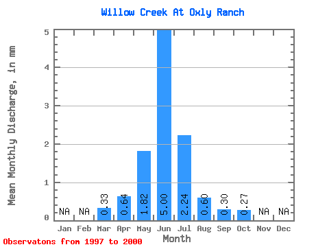
| Statistic | Jan | Feb | Mar | Apr | May | Jun | Jul | Aug | Sep | Oct | Nov | Dec | Annual |
|---|---|---|---|---|---|---|---|---|---|---|---|---|---|
| Mean | 0.33 | 0.64 | 1.82 | 5.00 | 2.24 | 0.60 | 0.30 | 0.27 | |||||
| Standard Deviation | 0.08 | 0.24 | 2.34 | 7.39 | 3.57 | 0.48 | 0.19 | 0.14 | |||||
| Min | 0.26 | 0.43 | 0.38 | 0.41 | 0.16 | 0.11 | 0.15 | 0.15 | |||||
| Max | 0.42 | 0.90 | 4.53 | 13.53 | 7.59 | 1.24 | 0.57 | 0.48 | |||||
| Coefficient of Variation | 0.25 | 0.38 | 1.29 | 1.48 | 1.59 | 0.80 | 0.62 | 0.53 |
 Return to R-Arctic Net Home Page