|
|
|||||||||||||||||
| Point ID: 7720 | Downloads | Plots | Site Data | Code: II004 |
|
|
|||||||||||||||||
| Download | |
|---|---|
| Site Descriptor Information | Site Time Series Data |
| Link to all available data | |
| View: | Time Series | All |
| Units: | m3/s |
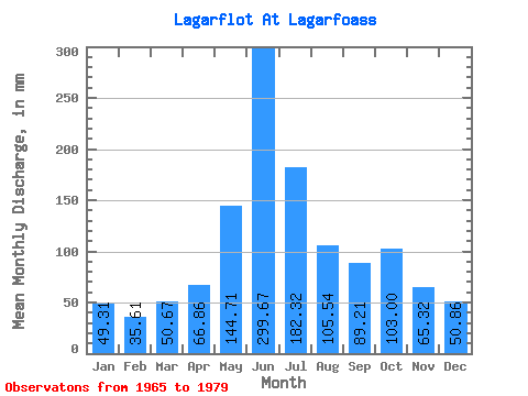
| Statistic | Jan | Feb | Mar | Apr | May | Jun | Jul | Aug | Sep | Oct | Nov | Dec | Annual |
|---|---|---|---|---|---|---|---|---|---|---|---|---|---|
| Mean | 49.30 | 35.91 | 50.66 | 66.86 | 144.69 | 299.67 | 182.29 | 105.52 | 89.21 | 102.98 | 65.32 | 50.85 | 1241.40 |
| Standard Deviation | 43.05 | 28.69 | 43.16 | 59.83 | 82.84 | 64.02 | 45.74 | 25.35 | 33.53 | 58.14 | 68.16 | 44.77 | 179.65 |
| Min | 7.56 | 8.98 | 5.26 | 15.55 | 16.74 | 179.59 | 93.16 | 76.04 | 40.73 | 41.13 | 14.35 | 9.36 | 840.38 |
| Max | 141.55 | 115.90 | 138.68 | 263.83 | 254.41 | 403.61 | 264.93 | 171.20 | 141.63 | 229.54 | 286.97 | 171.20 | 1527.94 |
| Coefficient of Variation | 0.87 | 0.80 | 0.85 | 0.90 | 0.57 | 0.21 | 0.25 | 0.24 | 0.38 | 0.56 | 1.04 | 0.88 | 0.14 |
 Return to R-Arctic Net Home Page