|
|
|||||||||||||||||
| Point ID: 7720 | Downloads | Plots | Site Data | Code: II004 |
|
|
|||||||||||||||||
| Download | |
|---|---|
| Site Descriptor Information | Site Time Series Data |
| Link to all available data | |
| View: | Time Series | All |
| Units: | mm |
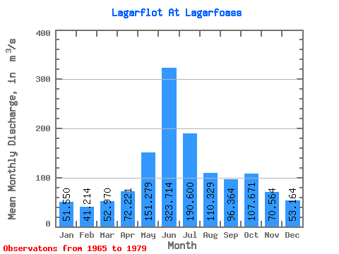
| Statistic | Jan | Feb | Mar | Apr | May | Jun | Jul | Aug | Sep | Oct | Nov | Dec | Annual |
|---|---|---|---|---|---|---|---|---|---|---|---|---|---|
| Mean | 51.55 | 41.21 | 52.97 | 72.22 | 151.28 | 323.71 | 190.60 | 110.33 | 96.36 | 107.67 | 70.56 | 53.16 | 110.14 |
| Standard Deviation | 45.01 | 32.93 | 45.12 | 64.63 | 86.61 | 69.16 | 47.82 | 26.50 | 36.22 | 60.79 | 73.62 | 46.81 | 15.94 |
| Min | 7.90 | 10.30 | 5.50 | 16.80 | 17.50 | 194.00 | 97.40 | 79.50 | 44.00 | 43.00 | 15.50 | 9.79 | 74.56 |
| Max | 148.00 | 133.00 | 145.00 | 285.00 | 266.00 | 436.00 | 277.00 | 179.00 | 153.00 | 240.00 | 310.00 | 179.00 | 135.56 |
| Coefficient of Variation | 0.87 | 0.80 | 0.85 | 0.90 | 0.57 | 0.21 | 0.25 | 0.24 | 0.38 | 0.56 | 1.04 | 0.88 | 0.14 |
 Return to R-Arctic Net Home Page