|
|
|||||||||||||||||
| Point ID: 7717 | Downloads | Plots | Site Data | Code: II001 |
|
|
|||||||||||||||||
| Download | |
|---|---|
| Site Descriptor Information | Site Time Series Data |
| Link to all available data | |
| View: | Time Series | All |
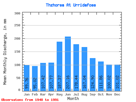
| Units: | m3/s |
| Statistic | Jan | Feb | Mar | Apr | May | Jun | Jul | Aug | Sep | Oct | Nov | Dec | Annual |
|---|---|---|---|---|---|---|---|---|---|---|---|---|---|
| Mean | 99.74 | 95.84 | 107.41 | 107.77 | 187.34 | 207.16 | 178.41 | 167.01 | 124.90 | 111.84 | 100.02 | 101.01 | 1586.77 |
| Standard Deviation | 22.52 | 23.37 | 43.96 | 38.60 | 56.57 | 66.50 | 44.69 | 36.62 | 29.39 | 24.51 | 23.52 | 23.13 | 189.39 |
| Min | 60.26 | 45.07 | 47.61 | 38.16 | 90.38 | 121.32 | 131.30 | 121.63 | 80.64 | 74.02 | 69.84 | 62.49 | 1268.61 |
| Max | 164.40 | 152.50 | 315.41 | 282.60 | 298.67 | 456.84 | 390.54 | 316.90 | 209.52 | 188.95 | 194.04 | 188.58 | 2092.31 |
| Coefficient of Variation | 0.23 | 0.24 | 0.41 | 0.36 | 0.30 | 0.32 | 0.25 | 0.22 | 0.23 | 0.22 | 0.23 | 0.23 | 0.12 |
 Return to R-Arctic Net Home Page