|
|
|||||||||||||||||
| Point ID: 7717 | Downloads | Plots | Site Data | Code: II001 |
|
|
|||||||||||||||||
| Download | |
|---|---|
| Site Descriptor Information | Site Time Series Data |
| Link to all available data | |
| View: | Time Series | All |
| Units: | mm |
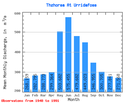
| Statistic | Jan | Feb | Mar | Apr | May | Jun | Jul | Aug | Sep | Oct | Nov | Dec | Annual |
|---|---|---|---|---|---|---|---|---|---|---|---|---|---|
| Mean | 268.16 | 282.80 | 288.77 | 299.36 | 503.68 | 575.46 | 479.68 | 449.02 | 346.95 | 300.70 | 277.84 | 271.57 | 362.00 |
| Standard Deviation | 60.55 | 68.96 | 118.20 | 107.24 | 152.08 | 184.73 | 120.15 | 98.45 | 81.64 | 65.91 | 65.33 | 62.19 | 43.21 |
| Min | 162.00 | 133.00 | 128.00 | 106.00 | 243.00 | 337.00 | 353.00 | 327.00 | 224.00 | 199.00 | 194.00 | 168.00 | 289.42 |
| Max | 442.00 | 450.00 | 848.00 | 785.00 | 803.00 | 1269.00 | 1050.00 | 852.00 | 582.00 | 508.00 | 539.00 | 507.00 | 477.33 |
| Coefficient of Variation | 0.23 | 0.24 | 0.41 | 0.36 | 0.30 | 0.32 | 0.25 | 0.22 | 0.23 | 0.22 | 0.23 | 0.23 | 0.12 |
 Return to R-Arctic Net Home Page