|
|
|||||||||||||||||
| Point ID: 7693 | Downloads | Plots | Site Data | Other Close Sites | Code: 15356000 |
|
|
|||||||||||||||||
| Download | |
|---|---|
| Site Descriptor Information | Site Time Series Data |
| Link to all available data | |
|
|
| View: | Statistics | Time Series |
| Units: | mm |
| Statistic | Jan | Feb | Mar | Apr | May | Jun | Jul | Aug | Sep | Oct | Nov | Dec | Annual |
|---|---|---|---|---|---|---|---|---|---|---|---|---|---|
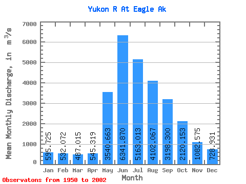
| Mean | 595.73 | 532.07 | 487.01 | 545.32 | 3540.66 | 6341.87 | 5163.01 | 4102.07 | 3198.30 | 2120.15 | 1082.58 | 728.93 | 2388.65 |
| Standard Deviation | 133.73 | 116.17 | 105.11 | 176.90 | 995.34 | 1797.14 | 1034.12 | 709.67 | 598.90 | 461.86 | 257.63 | 161.03 | 346.50 |
| Min | 254.85 | 203.88 | 220.87 | 244.94 | 1749.13 | 3423.51 | 3082.43 | 2511.98 | 2001.81 | 1298.89 | 679.60 | 368.12 | 1692.83 |
| Max | 860.47 | 792.87 | 721.51 | 1176.00 | 5705.85 | 12935.14 | 7631.39 | 5675.24 | 5319.79 | 3773.90 | 1769.80 | 1100.70 | 3113.18 |
| Coefficient of Variation | 0.22 | 0.22 | 0.22 | 0.32 | 0.28 | 0.28 | 0.20 | 0.17 | 0.19 | 0.22 | 0.24 | 0.22 | 0.14 |
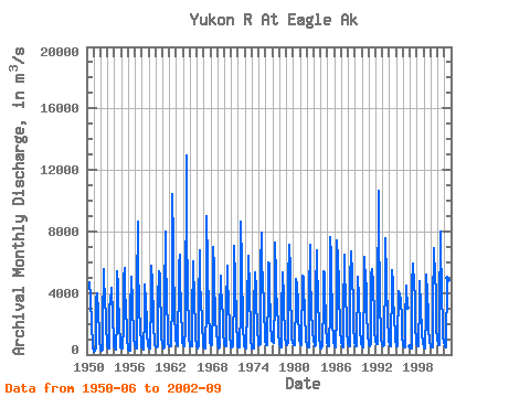
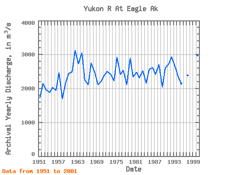
| Year | Jan | Feb | Mar | Apr | May | Jun | Jul | Aug | Sep | Oct | Nov | Dec | Annual | 1950 | 4709.09 | 3661.37 | 3157.33 | 2388.81 | 1686.84 | 792.87 | 368.12 | 1951 | 254.85 | 203.88 | 249.19 | 382.28 | 3652.87 | 3967.19 | 3989.84 | 2755.51 | 2388.53 | 1668.43 | 877.82 | 424.75 | 1734.60 | 1952 | 311.49 | 283.17 | 283.17 | 297.33 | 2015.03 | 5558.60 | 5119.69 | 3372.54 | 3120.52 | 2816.68 | 1769.80 | 772.77 | 2143.40 | 1953 | 509.70 | 481.39 | 424.75 | 424.75 | 3199.80 | 3423.51 | 4352.30 | 3270.60 | 3392.36 | 2180.40 | 1217.62 | 594.65 | 1955.99 | 1954 | 396.44 | 368.12 | 339.80 | 311.49 | 2269.88 | 5402.85 | 4394.77 | 3485.80 | 2450.82 | 1789.06 | 948.61 | 481.39 | 1886.59 | 1955 | 424.75 | 481.39 | 453.07 | 368.12 | 1859.00 | 4893.15 | 5606.74 | 4287.17 | 2843.01 | 1751.11 | 821.19 | 509.70 | 2024.87 | 1956 | 339.80 | 269.01 | 220.87 | 244.94 | 2786.09 | 5040.40 | 4428.76 | 3984.18 | 2827.44 | 1526.84 | 962.77 | 764.55 | 1949.64 | 1957 | 594.65 | 453.07 | 396.44 | 410.59 | 4230.54 | 8602.66 | 5394.36 | 3525.45 | 2978.93 | 1707.79 | 749.26 | 451.37 | 2457.93 | 1958 | 479.69 | 455.05 | 325.08 | 396.44 | 2413.16 | 4587.33 | 3508.46 | 3225.29 | 2350.30 | 1298.89 | 679.60 | 594.65 | 1692.83 | 1959 | 424.75 | 424.75 | 368.12 | 396.44 | 3757.65 | 5802.12 | 4703.43 | 3902.06 | 3140.34 | 1794.44 | 877.82 | 635.71 | 2185.64 | 1960 | 551.61 | 538.02 | 494.98 | 523.86 | 3910.56 | 4941.29 | 5417.01 | 5190.48 | 3805.78 | 2255.72 | 1019.41 | 735.39 | 2448.68 | 1961 | 664.88 | 515.65 | 423.90 | 453.07 | 3604.74 | 7982.52 | 5360.38 | 4508.04 | 3112.02 | 1980.76 | 764.55 | 538.02 | 2492.38 | 1962 | 594.65 | 594.65 | 566.34 | 538.02 | 3791.63 | 10465.91 | 7294.42 | 5031.90 | 3715.17 | 2543.99 | 1301.72 | 919.73 | 3113.18 | 1963 | 793.72 | 709.90 | 636.56 | 566.34 | 4997.92 | 5748.32 | 6476.06 | 4448.58 | 3533.94 | 2826.59 | 1288.42 | 736.24 | 2730.22 | 1964 | 651.29 | 622.97 | 538.02 | 509.70 | 1749.13 | 12935.14 | 7048.06 | 5281.09 | 3519.78 | 2081.29 | 962.77 | 679.60 | 3048.24 | 1965 | 566.34 | 538.02 | 509.70 | 566.34 | 2321.98 | 6039.98 | 5442.50 | 3995.51 | 3123.35 | 2124.61 | 934.46 | 679.60 | 2236.87 | 1966 | 509.70 | 424.75 | 424.75 | 509.70 | 3044.06 | 6796.04 | 4887.49 | 3228.12 | 2412.31 | 1906.57 | 736.24 | 566.34 | 2120.51 | 1967 | 481.39 | 424.75 | 368.12 | 368.12 | 3225.29 | 8990.60 | 5932.38 | 4510.87 | 3729.33 | 2532.66 | 1479.84 | 844.98 | 2740.69 | 1968 | 625.80 | 594.65 | 594.65 | 576.25 | 3021.41 | 6997.09 | 5535.94 | 4080.46 | 3321.57 | 2290.27 | 1366.85 | 873.29 | 2489.85 | 1969 | 618.44 | 494.41 | 378.03 | 485.07 | 2722.10 | 5142.34 | 4097.45 | 3522.62 | 3593.41 | 2246.66 | 1256.42 | 792.87 | 2112.48 | 1970 | 652.99 | 593.52 | 550.76 | 505.74 | 3078.04 | 5762.48 | 4686.44 | 3644.38 | 2939.29 | 2218.34 | 1153.35 | 652.14 | 2203.12 | 1971 | 499.79 | 481.39 | 517.91 | 551.33 | 4258.85 | 7076.38 | 4870.50 | 3947.37 | 3044.06 | 1924.70 | 891.98 | 535.19 | 2383.29 | 1972 | 481.39 | 481.39 | 453.07 | 453.07 | 2953.45 | 8673.45 | 5802.12 | 4372.12 | 3287.59 | 1738.37 | 759.74 | 523.29 | 2498.25 | 1973 | 494.98 | 440.04 | 396.44 | 415.41 | 3131.84 | 6393.94 | 6006.00 | 4544.85 | 3720.83 | 1918.18 | 920.30 | 566.34 | 2412.43 | 1974 | 424.75 | 424.75 | 424.75 | 424.75 | 3001.59 | 5312.24 | 4298.50 | 4768.56 | 3151.66 | 2113.29 | 1638.70 | 779.28 | 2230.24 | 1975 | 622.97 | 609.95 | 575.40 | 648.46 | 5606.74 | 7925.89 | 6266.52 | 4389.11 | 3556.60 | 2902.48 | 1170.34 | 795.70 | 2922.51 | 1976 | 667.14 | 620.99 | 589.27 | 664.88 | 4224.87 | 5966.36 | 5906.89 | 4111.61 | 2489.90 | 1897.51 | 1040.08 | 869.61 | 2420.76 | 1977 | 820.34 | 792.87 | 721.51 | 779.56 | 3664.20 | 7246.28 | 5037.57 | 4318.32 | 2973.27 | 2004.83 | 1194.12 | 884.34 | 2536.43 | 1978 | 710.75 | 575.40 | 471.48 | 470.06 | 2667.16 | 5337.73 | 4856.34 | 4188.06 | 2594.96 | 1738.37 | 1005.25 | 758.04 | 2114.47 | 1979 | 688.67 | 639.11 | 575.40 | 765.40 | 4890.32 | 6960.28 | 7099.03 | 5380.20 | 3567.92 | 2193.71 | 1114.83 | 743.60 | 2884.87 | 1980 | 658.65 | 634.58 | 590.97 | 708.77 | 3502.79 | 4918.64 | 4561.84 | 4290.00 | 3548.10 | 2536.62 | 1297.76 | 911.52 | 2346.69 | 1981 | 787.49 | 709.90 | 636.56 | 622.97 | 5136.68 | 5091.37 | 5012.08 | 3887.90 | 3293.25 | 2408.63 | 1296.06 | 818.36 | 2475.11 | 1982 | 650.44 | 491.58 | 476.01 | 453.07 | 3669.86 | 7116.02 | 4533.53 | 3570.75 | 2430.15 | 1949.33 | 1340.24 | 1072.36 | 2312.78 | 1983 | 841.29 | 656.38 | 558.12 | 622.97 | 4057.80 | 6801.71 | 4989.43 | 4638.30 | 3372.54 | 1995.49 | 993.07 | 656.67 | 2515.32 | 1984 | 476.86 | 397.29 | 408.33 | 546.51 | 3460.32 | 5400.02 | 5363.21 | 3440.50 | 2981.76 | 1704.67 | 978.91 | 732.56 | 2157.58 | 1985 | 613.91 | 548.21 | 518.76 | 509.70 | 2910.97 | 7631.39 | 6331.65 | 4420.26 | 3386.70 | 2030.60 | 1042.06 | 772.77 | 2559.75 | 1986 | 655.82 | 581.63 | 532.64 | 490.73 | 2628.94 | 7452.99 | 6156.08 | 4720.42 | 3491.47 | 2346.05 | 1447.84 | 946.35 | 2620.91 | 1987 | 728.03 | 598.62 | 506.02 | 453.07 | 2628.09 | 6518.54 | 5232.95 | 3981.35 | 3443.33 | 2630.07 | 1325.23 | 889.72 | 2411.25 | 1988 | 679.60 | 595.50 | 556.43 | 561.52 | 5255.61 | 6127.77 | 6730.91 | 5215.96 | 3233.78 | 1939.14 | 772.20 | 721.51 | 2699.16 | 1989 | 645.91 | 566.34 | 551.61 | 809.01 | 4612.81 | 5037.57 | 3715.17 | 3072.38 | 2372.67 | 1668.15 | 770.22 | 669.69 | 2040.96 | 1990 | 592.96 | 525.84 | 497.81 | 1176.00 | 4207.88 | 6311.82 | 4672.28 | 3788.79 | 4590.16 | 2848.68 | 1217.62 | 769.09 | 2599.91 | 1991 | 607.40 | 550.20 | 538.02 | 705.94 | 5193.31 | 5575.59 | 5405.69 | 4723.25 | 4015.33 | 2964.77 | 1332.87 | 1044.04 | 2721.37 | 1992 | 859.42 | 748.98 | 682.44 | 667.43 | 3270.60 | 10647.14 | 7631.39 | 4338.14 | 3083.70 | 1631.62 | 863.66 | 739.07 | 2930.30 | 1993 | 650.44 | 586.44 | 526.13 | 604.00 | 5705.85 | 7537.94 | 4929.96 | 3862.42 | 3109.19 | 2189.74 | 1177.13 | 827.70 | 2642.24 | 1994 | 682.44 | 615.89 | 565.49 | 1102.38 | 4139.92 | 5496.30 | 4621.31 | 3550.93 | 2559.84 | 2434.68 | 1327.21 | 876.97 | 2331.11 | 1995 | 670.54 | 565.20 | 518.76 | 835.35 | 4148.42 | 3899.23 | 3913.39 | 3533.94 | 3548.10 | 2245.81 | 1132.67 | 741.62 | 2146.09 | 1996 | 590.12 | 507.72 | 452.50 | 459.58 | 2108.76 | 4499.55 | 4020.99 | 3301.74 | 3063.88 | 1997 | 549.89 | 464.19 | 408.31 | 372.84 | 4468.58 | 5905.01 | 4814.78 | 5224.00 | 3062.18 | 1755.46 | 945.78 | 686.00 | 2388.09 | 1998 | 596.48 | 566.34 | 542.59 | 620.14 | 3368.43 | 4739.30 | 3082.43 | 2511.98 | 2001.81 | 1350.26 | 818.36 | 674.12 | 1739.35 | 1999 | 535.28 | 461.16 | 418.36 | 491.77 | 2654.02 | 5223.51 | 3973.49 | 3747.87 | 2746.92 | 1821.78 | 753.13 | 644.07 | 1955.95 | 2000 | 544.41 | 495.06 | 472.16 | 488.09 | 3197.15 | 6908.37 | 6152.06 | 5675.24 | 5319.79 | 3773.90 | 1514.01 | 1100.70 | 2970.08 | 2001 | 860.47 | 721.57 | 628.45 | 609.28 | 2780.53 | 7961.75 | 6386.82 | 4669.54 | 3529.22 | 2242.97 | 1168.54 | 809.31 | 2697.37 | 2002 | 642.15 | 542.07 | 466.77 | 437.97 | 4957.27 | 4636.41 | 3926.91 | 4815.69 | 4252.25 |
|---|
| Other Close Sites | ||||||
|---|---|---|---|---|---|---|
| PointID | Latitude | Longitude | Drainage Area | Source | Name | |
| 5832 | "YUKON RIVER AT EAGLE" | 64.78 | 2167698 | Hydat | ||
 Return to R-Arctic Net Home Page