|
|
|||||||||||||||||
| Point ID: 7681 | Downloads | Plots | Site Data | Code: 15476000 |
|
|
|||||||||||||||||
| Download | |
|---|---|
| Site Descriptor Information | Site Time Series Data |
| Link to all available data | |
|
|
| View: | Statistics | Time Series |
| Units: | mm |
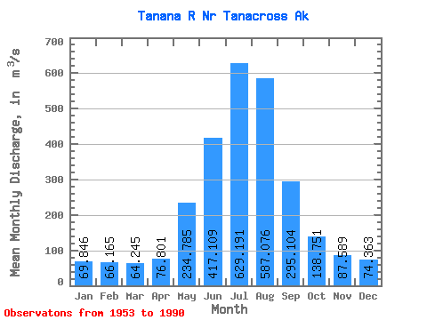
| Statistic | Jan | Feb | Mar | Apr | May | Jun | Jul | Aug | Sep | Oct | Nov | Dec | Annual |
|---|---|---|---|---|---|---|---|---|---|---|---|---|---|
| Mean | 69.85 | 66.17 | 64.25 | 76.80 | 234.78 | 417.11 | 629.19 | 587.08 | 295.10 | 138.75 | 87.59 | 74.36 | 227.44 |
| Standard Deviation | 9.29 | 8.65 | 9.17 | 16.57 | 55.51 | 108.60 | 98.07 | 108.87 | 60.42 | 26.82 | 14.14 | 10.60 | 28.35 |
| Min | 48.11 | 45.28 | 39.62 | 51.59 | 112.04 | 247.97 | 455.91 | 335.64 | 182.68 | 73.58 | 62.06 | 54.42 | 170.96 |
| Max | 89.09 | 87.73 | 87.73 | 126.70 | 369.03 | 705.52 | 983.42 | 843.62 | 425.92 | 201.01 | 125.65 | 100.78 | 294.88 |
| Coefficient of Variation | 0.13 | 0.13 | 0.14 | 0.22 | 0.24 | 0.26 | 0.16 | 0.18 | 0.20 | 0.19 | 0.16 | 0.14 | 0.12 |
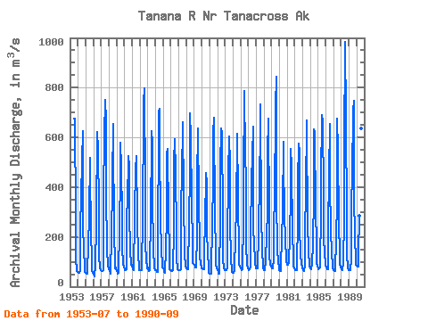
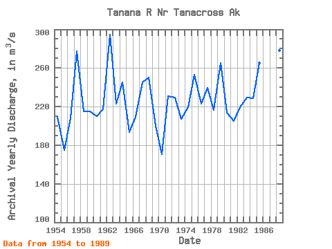
| Year | Jan | Feb | Mar | Apr | May | Jun | Jul | Aug | Sep | Oct | Nov | Dec | Annual | 1953 | 676.65 | 675.24 | 282.24 | 116.99 | 62.06 | 59.43 | 1954 | 56.60 | 53.77 | 53.77 | 62.26 | 242.93 | 361.39 | 504.59 | 625.43 | 263.33 | 130.07 | 96.22 | 58.07 | 209.04 | 1955 | 56.60 | 51.14 | 52.50 | 69.33 | 159.58 | 290.64 | 517.89 | 457.61 | 227.25 | 98.82 | 65.09 | 56.60 | 175.25 | 1956 | 48.11 | 45.28 | 39.62 | 83.48 | 252.78 | 271.57 | 621.47 | 554.96 | 310.17 | 118.86 | 77.83 | 66.36 | 207.54 | 1957 | 62.26 | 62.26 | 62.26 | 67.92 | 369.03 | 607.60 | 751.37 | 665.33 | 378.09 | 147.98 | 87.73 | 70.75 | 277.71 | 1958 | 76.41 | 65.49 | 50.77 | 72.87 | 179.39 | 427.61 | 653.45 | 587.23 | 239.81 | 73.58 | 79.24 | 73.58 | 214.95 | 1959 | 62.26 | 56.60 | 50.94 | 56.60 | 226.15 | 456.20 | 579.58 | 480.25 | 285.26 | 156.92 | 90.56 | 79.16 | 215.04 | 1960 | 70.89 | 65.09 | 67.16 | 68.37 | 292.62 | 336.49 | 526.66 | 482.51 | 292.62 | 148.15 | 89.14 | 84.90 | 210.38 | 1961 | 86.26 | 68.12 | 66.65 | 64.52 | 278.16 | 494.97 | 485.06 | 525.81 | 266.25 | 126.92 | 76.41 | 67.92 | 217.25 | 1962 | 67.92 | 67.92 | 65.09 | 68.00 | 284.42 | 697.88 | 740.89 | 799.19 | 400.16 | 165.07 | 108.42 | 73.58 | 294.88 | 1963 | 76.41 | 73.58 | 62.26 | 68.00 | 300.26 | 247.97 | 624.01 | 574.21 | 350.35 | 157.66 | 73.58 | 65.09 | 222.78 | 1964 | 70.75 | 65.09 | 59.43 | 59.43 | 112.04 | 705.52 | 714.58 | 572.79 | 272.36 | 149.85 | 84.90 | 76.55 | 245.27 | 1965 | 72.50 | 65.09 | 59.43 | 56.60 | 147.30 | 280.74 | 532.61 | 552.42 | 280.60 | 136.60 | 70.75 | 65.09 | 193.31 | 1966 | 65.09 | 62.26 | 62.26 | 65.09 | 234.86 | 499.78 | 593.45 | 468.37 | 209.79 | 113.11 | 70.75 | 67.92 | 209.39 | 1967 | 65.09 | 65.09 | 65.09 | 70.75 | 266.13 | 506.57 | 593.45 | 663.07 | 359.98 | 125.51 | 85.38 | 79.52 | 245.47 | 1968 | 72.11 | 70.75 | 70.75 | 71.85 | 248.30 | 471.48 | 698.44 | 601.38 | 346.96 | 164.37 | 94.04 | 89.97 | 250.03 | 1969 | 87.08 | 82.78 | 77.97 | 78.48 | 209.39 | 423.08 | 635.05 | 335.64 | 182.68 | 118.72 | 91.89 | 81.25 | 200.33 | 1970 | 75.05 | 73.58 | 70.75 | 71.32 | 153.78 | 250.14 | 455.91 | 413.75 | 222.61 | 133.86 | 76.33 | 54.42 | 170.96 | 1971 | 50.94 | 50.94 | 50.94 | 57.51 | 251.98 | 416.29 | 614.96 | 680.90 | 296.02 | 135.27 | 87.64 | 75.14 | 230.71 | 1972 | 65.91 | 58.16 | 51.85 | 51.59 | 262.00 | 476.86 | 634.49 | 619.77 | 283.85 | 109.27 | 75.00 | 66.93 | 229.64 | 1973 | 65.09 | 65.09 | 65.09 | 72.22 | 186.19 | 446.57 | 604.77 | 490.16 | 258.12 | 109.55 | 69.53 | 57.51 | 207.49 | 1974 | 56.60 | 56.60 | 60.99 | 76.78 | 194.87 | 321.77 | 594.02 | 616.09 | 365.07 | 119.91 | 91.97 | 80.51 | 219.60 | 1975 | 72.02 | 65.60 | 65.09 | 69.28 | 265.09 | 419.69 | 786.17 | 532.32 | 425.92 | 163.26 | 92.74 | 75.22 | 252.70 | 1976 | 70.75 | 67.92 | 68.91 | 77.54 | 219.18 | 423.65 | 524.12 | 643.83 | 227.81 | 181.66 | 97.64 | 74.94 | 223.16 | 1977 | 73.58 | 73.58 | 72.11 | 85.66 | 202.63 | 453.08 | 590.34 | 733.25 | 284.98 | 148.15 | 81.14 | 73.58 | 239.34 | 1978 | 67.92 | 67.10 | 65.09 | 101.40 | 212.65 | 291.21 | 532.89 | 675.80 | 291.77 | 123.64 | 87.73 | 80.15 | 216.44 | 1979 | 74.68 | 73.58 | 73.58 | 110.94 | 255.52 | 345.54 | 721.65 | 843.62 | 352.33 | 153.50 | 98.12 | 76.33 | 264.95 | 1980 | 67.92 | 62.26 | 64.27 | 89.63 | 186.55 | 311.30 | 582.70 | 500.63 | 293.75 | 188.28 | 113.11 | 100.78 | 213.43 | 1981 | 89.09 | 87.73 | 87.73 | 96.22 | 202.20 | 371.86 | 553.26 | 482.23 | 220.63 | 112.83 | 84.70 | 74.12 | 205.22 | 1982 | 68.66 | 67.92 | 65.09 | 65.66 | 285.83 | 421.39 | 576.47 | 537.98 | 241.99 | 128.68 | 92.63 | 80.15 | 219.37 | 1983 | 71.74 | 66.19 | 62.71 | 89.14 | 220.74 | 378.94 | 668.45 | 617.22 | 269.27 | 130.18 | 93.39 | 80.51 | 229.04 | 1984 | 73.50 | 69.39 | 72.84 | 86.31 | 172.09 | 366.20 | 632.22 | 618.92 | 309.32 | 165.92 | 97.15 | 81.08 | 228.75 | 1985 | 74.94 | 70.75 | 72.67 | 77.63 | 309.60 | 425.63 | 691.37 | 665.90 | 370.45 | 201.01 | 125.65 | 98.60 | 265.35 | 1986 | 83.99 | 75.39 | 68.83 | 70.83 | 231.61 | 447.71 | 655.71 | 407.80 | 234.75 | 129.81 | 88.30 | 73.41 | 214.01 | 1987 | 65.00 | 62.26 | 62.26 | 78.39 | 179.71 | 351.49 | 675.52 | 549.02 | 255.41 | 130.09 | 90.08 | 76.41 | 214.64 | 1988 | 70.10 | 67.92 | 66.00 | 93.31 | 272.56 | 556.38 | 983.42 | 674.67 | 276.12 | 133.94 | 74.15 | 67.92 | 278.04 | 1989 | 67.92 | 65.09 | 65.09 | 110.00 | 333.94 | 444.88 | 709.20 | 745.71 | 381.77 | 185.76 | 119.79 | 88.01 | 276.43 | 1990 | 82.55 | 80.77 | 79.24 | 126.70 | 284.98 | 432.99 | 672.41 | 637.88 | 404.12 |
|---|
 Return to R-Arctic Net Home Page