|
|
|||||||||||||||||
| Point ID: 7680 | Downloads | Plots | Site Data | Code: 15472000 |
|
|
|||||||||||||||||
| Download | |
|---|---|
| Site Descriptor Information | Site Time Series Data |
| Link to all available data | |
|
|
| View: | Statistics | Time Series |
| Units: | mm |
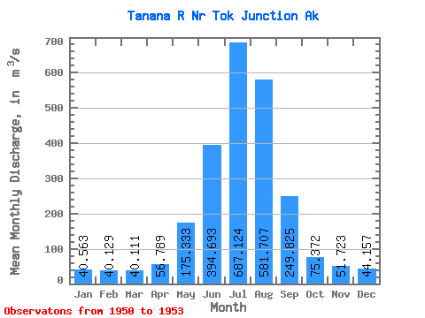
| Statistic | Jan | Feb | Mar | Apr | May | Jun | Jul | Aug | Sep | Oct | Nov | Dec | Annual |
|---|---|---|---|---|---|---|---|---|---|---|---|---|---|
| Mean | 40.56 | 40.13 | 40.11 | 56.79 | 175.33 | 394.69 | 687.12 | 581.71 | 249.82 | 75.37 | 51.72 | 44.16 | 185.35 |
| Standard Deviation | 1.63 | 4.53 | 4.54 | 16.10 | 46.84 | 109.01 | 68.22 | 93.04 | 91.11 | 14.12 | 9.49 | 5.99 | 8.68 |
| Min | 39.62 | 36.79 | 36.79 | 44.43 | 127.29 | 244.14 | 601.38 | 500.91 | 163.57 | 59.06 | 43.87 | 39.62 | 179.21 |
| Max | 42.45 | 45.28 | 45.28 | 75.00 | 237.66 | 498.08 | 757.87 | 672.41 | 372.99 | 83.54 | 62.26 | 50.94 | 191.49 |
| Coefficient of Variation | 0.04 | 0.11 | 0.11 | 0.28 | 0.27 | 0.28 | 0.10 | 0.16 | 0.36 | 0.19 | 0.18 | 0.14 | 0.05 |
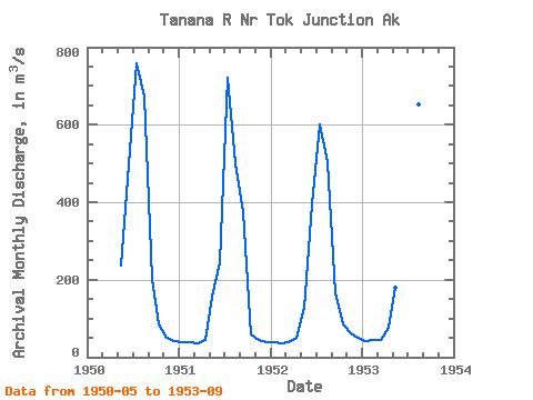
| Year | Jan | Feb | Mar | Apr | May | Jun | Jul | Aug | Sep | Oct | Nov | Dec | Annual | 1950 | 237.66 | 498.08 | 757.87 | 672.41 | 203.00 | 83.51 | 49.04 | 41.91 | 1951 | 39.62 | 38.32 | 36.79 | 44.43 | 156.22 | 244.14 | 721.93 | 500.91 | 372.99 | 59.06 | 43.87 | 39.62 | 191.49 | 1952 | 39.62 | 36.79 | 38.26 | 50.94 | 127.29 | 393.94 | 601.38 | 502.04 | 163.57 | 83.54 | 62.26 | 50.94 | 179.21 | 1953 | 42.45 | 45.28 | 45.28 | 75.00 | 180.16 | 442.61 | 667.31 | 651.47 | 259.74 |
|---|
 Return to R-Arctic Net Home Page