|
|
|||||||||||||||||
| Point ID: 7680 | Downloads | Plots | Site Data | Code: 15472000 |
|
|
|||||||||||||||||
| Download | |
|---|---|
| Site Descriptor Information | Site Time Series Data |
| Link to all available data | |
|
|
| View: | Statistics | Time Series |
| Units: | m3/s |
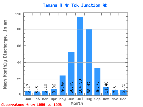
| Statistic | Jan | Feb | Mar | Apr | May | Jun | Jul | Aug | Sep | Oct | Nov | Dec | Annual |
|---|---|---|---|---|---|---|---|---|---|---|---|---|---|
| Mean | 6.17 | 5.56 | 6.10 | 8.36 | 26.66 | 58.09 | 104.48 | 88.45 | 36.77 | 11.46 | 7.61 | 6.71 | 332.15 |
| Standard Deviation | 0.25 | 0.63 | 0.69 | 2.37 | 7.12 | 16.04 | 10.37 | 14.15 | 13.41 | 2.15 | 1.40 | 0.91 | 15.56 |
| Min | 6.02 | 5.10 | 5.59 | 6.54 | 19.36 | 35.93 | 91.44 | 76.17 | 24.07 | 8.98 | 6.46 | 6.02 | 321.15 |
| Max | 6.46 | 6.27 | 6.88 | 11.04 | 36.14 | 73.30 | 115.24 | 102.24 | 54.90 | 12.70 | 9.16 | 7.75 | 343.15 |
| Coefficient of Variation | 0.04 | 0.11 | 0.11 | 0.28 | 0.27 | 0.28 | 0.10 | 0.16 | 0.36 | 0.19 | 0.18 | 0.14 | 0.05 |
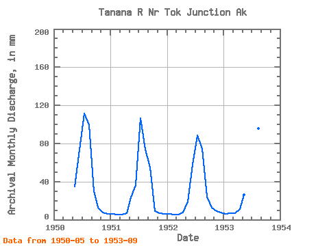
| Year | Jan | Feb | Mar | Apr | May | Jun | Jul | Aug | Sep | Oct | Nov | Dec | Annual | 1950 | 36.14 | 73.30 | 115.24 | 102.24 | 29.88 | 12.70 | 7.22 | 6.37 | 1951 | 6.02 | 5.31 | 5.59 | 6.54 | 23.75 | 35.93 | 109.77 | 76.17 | 54.90 | 8.98 | 6.46 | 6.02 | 343.15 | 1952 | 6.02 | 5.10 | 5.82 | 7.50 | 19.36 | 57.98 | 91.44 | 76.34 | 24.07 | 12.70 | 9.16 | 7.75 | 321.15 | 1953 | 6.46 | 6.27 | 6.88 | 11.04 | 27.39 | 65.14 | 101.47 | 99.06 | 38.23 |
|---|
 Return to R-Arctic Net Home Page