|
|
|||||||||||||||||
| Point ID: 7678 | Downloads | Plots | Site Data | Code: 15389500 |
|
|
|||||||||||||||||
| Download | |
|---|---|
| Site Descriptor Information | Site Time Series Data |
| Link to all available data | |
|
|
| View: | Statistics | Time Series |
| Units: | mm |
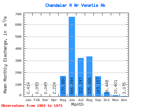
| Statistic | Jan | Feb | Mar | Apr | May | Jun | Jul | Aug | Sep | Oct | Nov | Dec | Annual |
|---|---|---|---|---|---|---|---|---|---|---|---|---|---|
| Mean | 0.41 | 0.09 | 0.05 | 2.22 | 170.88 | 666.24 | 322.30 | 335.67 | 169.16 | 36.45 | 10.40 | 3.08 | 136.57 |
| Standard Deviation | 1.01 | 0.19 | 0.10 | 2.96 | 169.26 | 216.76 | 101.38 | 165.02 | 85.39 | 20.40 | 8.48 | 3.46 | 31.12 |
| Min | 0.00 | 0.00 | 0.00 | 0.01 | 2.17 | 265.51 | 161.73 | 150.53 | 75.98 | 8.49 | 0.52 | 0.14 | 79.50 |
| Max | 3.28 | 0.58 | 0.28 | 8.69 | 523.55 | 954.84 | 495.53 | 567.13 | 382.62 | 65.71 | 26.29 | 11.49 | 182.16 |
| Coefficient of Variation | 2.45 | 2.08 | 1.95 | 1.33 | 0.99 | 0.33 | 0.32 | 0.49 | 0.51 | 0.56 | 0.81 | 1.13 | 0.23 |
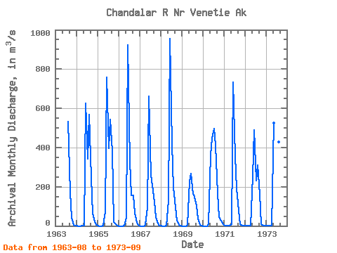
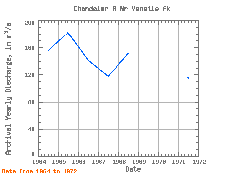
| Year | Jan | Feb | Mar | Apr | May | Jun | Jul | Aug | Sep | Oct | Nov | Dec | Annual | 1963 | 531.76 | 171.13 | 42.90 | 7.08 | 1.40 | 1964 | 0.11 | 0.00 | 0.00 | 0.01 | 2.17 | 624.86 | 341.86 | 567.13 | 246.44 | 63.73 | 20.66 | 5.01 | 156.00 | 1965 | 0.09 | 0.00 | 0.00 | 0.19 | 72.02 | 757.87 | 397.33 | 542.51 | 382.62 | 20.52 | 9.34 | 3.40 | 182.16 | 1966 | 0.00 | 0.00 | 0.00 | 1.70 | 41.18 | 924.56 | 328.85 | 156.56 | 155.62 | 65.71 | 16.98 | 4.81 | 141.33 | 1967 | 0.00 | 0.00 | 0.00 | 5.94 | 96.22 | 661.09 | 259.96 | 206.11 | 123.73 | 46.30 | 10.84 | 2.76 | 117.75 | 1968 | 0.28 | 0.00 | 0.00 | 0.54 | 126.16 | 954.84 | 417.71 | 195.89 | 94.04 | 25.10 | 5.58 | 0.75 | 151.74 | 1969 | 0.00 | 0.00 | 0.00 | 3.62 | 226.46 | 265.51 | 161.73 | 150.53 | 101.14 | 38.26 | 6.03 | 0.72 | 79.50 | 1970 | 0.00 | 0.00 | 0.00 | 8.69 | 359.41 | 446.29 | 495.53 | 408.65 | 166.04 | 44.74 | 26.29 | 11.49 | 163.93 | 1971 | 3.28 | 0.58 | 0.15 | 0.41 | 10.44 | 734.67 | 356.86 | 193.43 | 75.98 | 8.72 | 0.52 | 0.14 | 115.43 | 1972 | 0.09 | 0.07 | 0.06 | 0.05 | 251.19 | 491.00 | 229.43 | 311.02 | 163.52 | 8.49 | 0.71 | 0.28 | 121.33 | 1973 | 0.28 | 0.28 | 0.28 | 1.08 | 523.55 | 801.74 | 233.70 | 428.75 | 180.47 |
|---|
 Return to R-Arctic Net Home Page