|
|
|||||||||||||||||
| Point ID: 7648 | Downloads | Plots | Site Data | Code: 71221 |
|
|
|||||||||||||||||
| Download | |
|---|---|
| Site Descriptor Information | Site Time Series Data |
| Link to all available data | |
| View: | Time Series | All |
| Units: | m3/s |
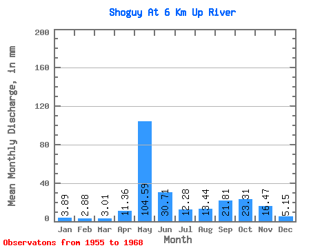
| Statistic | Jan | Feb | Mar | Apr | May | Jun | Jul | Aug | Sep | Oct | Nov | Dec | Annual |
|---|---|---|---|---|---|---|---|---|---|---|---|---|---|
| Mean | 3.89 | 2.91 | 3.00 | 11.37 | 104.58 | 30.71 | 12.29 | 13.43 | 21.80 | 23.31 | 16.48 | 5.15 | 248.35 |
| Standard Deviation | 1.90 | 1.01 | 1.00 | 14.22 | 33.82 | 19.27 | 8.60 | 10.63 | 17.11 | 15.27 | 12.15 | 3.17 | 60.55 |
| Min | 1.83 | 1.41 | 1.88 | 1.59 | 32.70 | 5.98 | 3.86 | 3.60 | 4.24 | 3.60 | 2.12 | 1.67 | 126.11 |
| Max | 7.98 | 4.46 | 5.15 | 46.85 | 165.57 | 81.00 | 32.19 | 43.00 | 55.58 | 55.10 | 42.87 | 13.13 | 315.35 |
| Coefficient of Variation | 0.49 | 0.35 | 0.33 | 1.25 | 0.32 | 0.63 | 0.70 | 0.79 | 0.79 | 0.66 | 0.74 | 0.62 | 0.24 |
 Return to R-Arctic Net Home Page