|
|
|||||||||||||||||
| Point ID: 7648 | Downloads | Plots | Site Data | Code: 71221 |
|
|
|||||||||||||||||
| Download | |
|---|---|
| Site Descriptor Information | Site Time Series Data |
| Link to all available data | |
| View: | Time Series | All |
| Units: | mm |
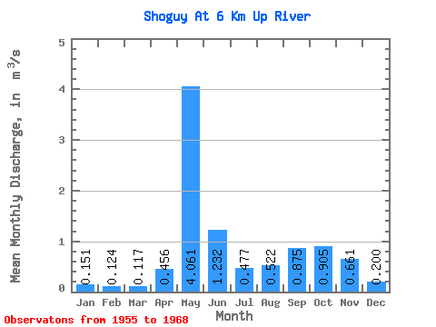
| Statistic | Jan | Feb | Mar | Apr | May | Jun | Jul | Aug | Sep | Oct | Nov | Dec | Annual |
|---|---|---|---|---|---|---|---|---|---|---|---|---|---|
| Mean | 0.15 | 0.12 | 0.12 | 0.46 | 4.06 | 1.23 | 0.48 | 0.52 | 0.88 | 0.91 | 0.66 | 0.20 | 0.82 |
| Standard Deviation | 0.07 | 0.04 | 0.04 | 0.57 | 1.31 | 0.77 | 0.33 | 0.41 | 0.69 | 0.59 | 0.49 | 0.12 | 0.20 |
| Min | 0.07 | 0.06 | 0.07 | 0.06 | 1.27 | 0.24 | 0.15 | 0.14 | 0.17 | 0.14 | 0.09 | 0.07 | 0.42 |
| Max | 0.31 | 0.19 | 0.20 | 1.88 | 6.43 | 3.25 | 1.25 | 1.67 | 2.23 | 2.14 | 1.72 | 0.51 | 1.04 |
| Coefficient of Variation | 0.49 | 0.35 | 0.33 | 1.25 | 0.32 | 0.63 | 0.70 | 0.79 | 0.79 | 0.66 | 0.74 | 0.62 | 0.24 |
 Return to R-Arctic Net Home Page