|
|
|||||||||||||||||
| Point ID: 7642 | Downloads | Plots | Site Data | Code: 71193 |
|
|
|||||||||||||||||
| Download | |
|---|---|
| Site Descriptor Information | Site Time Series Data |
| Link to all available data | |
| View: | Time Series | All |
| Units: | m3/s |
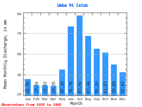
| Statistic | Jan | Feb | Mar | Apr | May | Jun | Jul | Aug | Sep | Oct | Nov | Dec | Annual |
|---|---|---|---|---|---|---|---|---|---|---|---|---|---|
| Mean | 25.95 | 20.03 | 19.92 | 19.35 | 35.15 | 76.76 | 87.40 | 67.44 | 55.20 | 51.57 | 39.89 | 32.59 | 528.54 |
| Standard Deviation | 5.59 | 4.12 | 3.84 | 3.37 | 12.29 | 18.67 | 22.66 | 18.09 | 15.40 | 15.19 | 11.00 | 8.26 | 92.12 |
| Min | 12.27 | 9.07 | 9.61 | 10.28 | 15.64 | 44.33 | 38.59 | 28.92 | 24.18 | 21.83 | 16.55 | 13.84 | 315.49 |
| Max | 37.58 | 28.40 | 28.47 | 26.36 | 69.20 | 119.80 | 148.53 | 106.33 | 91.16 | 104.42 | 63.93 | 55.36 | 746.68 |
| Coefficient of Variation | 0.22 | 0.21 | 0.19 | 0.17 | 0.35 | 0.24 | 0.26 | 0.27 | 0.28 | 0.29 | 0.28 | 0.25 | 0.17 |
 Return to R-Arctic Net Home Page