|
|
|||||||||||||||||
| Point ID: 7642 | Downloads | Plots | Site Data | Code: 71193 |
|
|
|||||||||||||||||
| Download | |
|---|---|
| Site Descriptor Information | Site Time Series Data |
| Link to all available data | |
| View: | Time Series | All |
| Units: | mm |
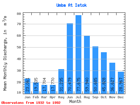
| Statistic | Jan | Feb | Mar | Apr | May | Jun | Jul | Aug | Sep | Oct | Nov | Dec | Annual |
|---|---|---|---|---|---|---|---|---|---|---|---|---|---|
| Mean | 23.06 | 19.54 | 17.70 | 17.77 | 31.23 | 70.48 | 77.67 | 59.94 | 50.69 | 45.83 | 36.63 | 28.97 | 39.86 |
| Standard Deviation | 4.97 | 4.02 | 3.41 | 3.10 | 10.92 | 17.14 | 20.14 | 16.07 | 14.14 | 13.50 | 10.10 | 7.34 | 6.95 |
| Min | 10.90 | 8.85 | 8.54 | 9.44 | 13.90 | 40.70 | 34.30 | 25.70 | 22.20 | 19.40 | 15.20 | 12.30 | 23.79 |
| Max | 33.40 | 27.70 | 25.30 | 24.20 | 61.50 | 110.00 | 132.00 | 94.50 | 83.70 | 92.80 | 58.70 | 49.20 | 56.31 |
| Coefficient of Variation | 0.22 | 0.21 | 0.19 | 0.17 | 0.35 | 0.24 | 0.26 | 0.27 | 0.28 | 0.29 | 0.28 | 0.25 | 0.17 |
 Return to R-Arctic Net Home Page