|
|
|||||||||||||||||
| Point ID: 7609 | Downloads | Plots | Site Data | Code: 71134 |
|
|
|||||||||||||||||
| Download | |
|---|---|
| Site Descriptor Information | Site Time Series Data |
| Link to all available data | |
|
|
| View: | Statistics | Time Series |
| Units: | mm |
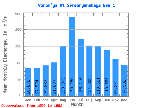
| Statistic | Jan | Feb | Mar | Apr | May | Jun | Jul | Aug | Sep | Oct | Nov | Dec | Annual |
|---|---|---|---|---|---|---|---|---|---|---|---|---|---|
| Mean | 68.67 | 67.57 | 74.33 | 81.70 | 120.90 | 190.29 | 138.12 | 121.30 | 119.66 | 110.88 | 89.32 | 74.58 | 105.04 |
| Standard Deviation | 36.92 | 41.61 | 42.06 | 51.19 | 106.50 | 135.88 | 59.72 | 42.78 | 40.04 | 40.95 | 33.51 | 33.38 | 20.06 |
| Min | 19.40 | 15.00 | 13.60 | 13.80 | 16.80 | 33.70 | 36.10 | 20.30 | 40.00 | 34.50 | 28.50 | 19.70 | 46.89 |
| Max | 153.00 | 160.00 | 155.00 | 202.00 | 462.00 | 548.00 | 290.00 | 210.00 | 188.00 | 187.00 | 168.00 | 153.00 | 143.78 |
| Coefficient of Variation | 0.54 | 0.62 | 0.57 | 0.63 | 0.88 | 0.71 | 0.43 | 0.35 | 0.34 | 0.37 | 0.38 | 0.45 | 0.19 |
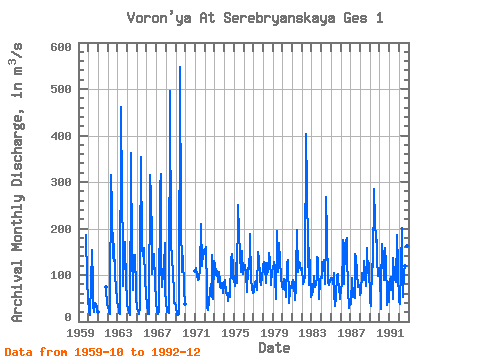
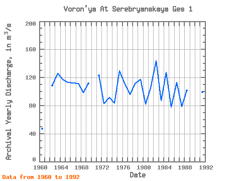
| Year | Jan | Feb | Mar | Apr | May | Jun | Jul | Aug | Sep | Oct | Nov | Dec | Annual | 1959 | 185.00 | 90.60 | 44.30 | 1960 | 27.40 | 22.00 | 14.70 | 82.60 | 154.00 | 79.80 | 36.10 | 20.30 | 40.00 | 37.60 | 28.50 | 19.70 | 46.89 | 1961 | 19.40 | 75.10 | 71.30 | 35.30 | 1962 | 32.90 | 22.80 | 16.20 | 23.00 | 315.00 | 241.00 | 141.00 | 131.00 | 167.00 | 97.60 | 71.90 | 46.50 | 108.83 | 1963 | 31.40 | 26.70 | 19.10 | 16.80 | 462.00 | 272.00 | 154.00 | 76.90 | 148.00 | 171.00 | 76.00 | 55.70 | 125.80 | 1964 | 36.40 | 26.20 | 19.80 | 14.90 | 329.00 | 362.00 | 146.00 | 67.20 | 143.00 | 142.00 | 70.10 | 51.90 | 117.38 | 1965 | 26.40 | 23.80 | 15.90 | 30.20 | 145.00 | 353.00 | 161.00 | 141.00 | 159.00 | 155.00 | 87.80 | 60.90 | 113.25 | 1966 | 32.80 | 22.60 | 17.00 | 15.30 | 316.00 | 269.00 | 182.00 | 102.00 | 120.00 | 145.00 | 86.90 | 39.30 | 112.33 | 1967 | 22.30 | 20.00 | 16.70 | 23.10 | 290.00 | 317.00 | 121.00 | 74.50 | 107.00 | 119.00 | 168.00 | 62.70 | 111.78 | 1968 | 42.80 | 21.40 | 19.40 | 18.40 | 35.70 | 495.00 | 153.00 | 152.00 | 87.20 | 80.80 | 39.10 | 38.90 | 98.64 | 1969 | 31.20 | 15.00 | 13.60 | 13.80 | 16.80 | 548.00 | 218.00 | 107.00 | 124.00 | 140.00 | 68.70 | 37.70 | 111.15 | 1970 | 1971 | 109.00 | 114.00 | 99.90 | 89.20 | 91.70 | 96.50 | 111.00 | 210.00 | 119.00 | 146.00 | 135.00 | 153.00 | 122.86 | 1972 | 153.00 | 160.00 | 65.50 | 30.90 | 24.30 | 41.10 | 63.20 | 81.30 | 52.80 | 142.00 | 47.70 | 131.00 | 82.73 | 1973 | 124.00 | 101.00 | 112.00 | 106.00 | 85.80 | 107.00 | 87.00 | 74.00 | 72.10 | 83.80 | 62.00 | 77.90 | 91.05 | 1974 | 83.60 | 88.20 | 61.40 | 56.40 | 61.80 | 44.90 | 58.40 | 53.40 | 132.00 | 146.00 | 122.00 | 92.10 | 83.35 | 1975 | 92.20 | 76.40 | 120.00 | 133.00 | 82.30 | 251.00 | 192.00 | 142.00 | 106.00 | 107.00 | 152.00 | 103.00 | 129.74 | 1976 | 114.00 | 122.00 | 120.00 | 103.00 | 63.80 | 116.00 | 113.00 | 155.00 | 188.00 | 90.00 | 71.90 | 60.80 | 109.79 | 1977 | 76.60 | 62.80 | 82.00 | 86.90 | 67.50 | 150.00 | 128.00 | 141.00 | 89.60 | 77.70 | 96.60 | 88.40 | 95.59 | 1978 | 121.00 | 127.00 | 102.00 | 126.00 | 82.50 | 118.00 | 106.00 | 147.00 | 133.00 | 90.00 | 78.70 | 108.00 | 111.60 | 1979 | 112.00 | 128.00 | 106.00 | 95.00 | 49.00 | 195.00 | 107.00 | 148.00 | 169.00 | 131.00 | 95.20 | 74.40 | 117.47 | 1980 | 70.00 | 90.80 | 83.70 | 80.00 | 52.10 | 129.00 | 92.20 | 133.00 | 40.80 | 67.70 | 76.40 | 72.80 | 82.38 | 1981 | 82.80 | 89.60 | 80.50 | 45.80 | 72.40 | 108.00 | 197.00 | 106.00 | 128.00 | 123.00 | 116.00 | 111.00 | 105.01 | 1982 | 114.00 | 80.40 | 84.40 | 98.60 | 102.00 | 404.00 | 290.00 | 153.00 | 79.40 | 157.00 | 109.00 | 53.60 | 143.78 | 1983 | 57.20 | 71.60 | 63.70 | 98.70 | 74.30 | 78.30 | 96.10 | 139.00 | 134.00 | 48.00 | 86.40 | 96.10 | 86.95 | 1984 | 94.10 | 128.00 | 120.00 | 132.00 | 79.80 | 180.00 | 267.00 | 187.00 | 83.60 | 77.80 | 87.90 | 86.10 | 126.94 | 1985 | 94.10 | 93.70 | 81.20 | 105.00 | 58.60 | 33.70 | 53.20 | 99.70 | 103.00 | 90.10 | 73.80 | 49.40 | 77.96 | 1986 | 69.90 | 79.30 | 155.00 | 175.00 | 80.60 | 164.00 | 174.00 | 180.00 | 142.00 | 70.20 | 30.00 | 38.80 | 113.23 | 1987 | 37.20 | 37.80 | 93.40 | 52.90 | 61.90 | 51.60 | 146.00 | 138.00 | 106.00 | 73.20 | 77.90 | 66.60 | 78.54 | 1988 | 56.80 | 60.30 | 105.00 | 104.00 | 89.60 | 130.00 | 103.00 | 77.40 | 158.00 | 105.00 | 105.00 | 126.00 | 101.67 | 1989 | 42.50 | 32.40 | 123.00 | 123.00 | 117.00 | 286.00 | 218.00 | 172.00 | 175.00 | 135.00 | 97.10 | 114.00 | 136.25 | 1990 | 102.00 | 25.90 | 78.80 | 166.00 | 138.00 | 88.30 | 159.00 | 141.00 | 140.00 | 34.50 | 84.10 | 42.30 | 99.99 | 1991 | 45.40 | 87.60 | 96.40 | 85.10 | 47.50 | 137.00 | 99.40 | 91.70 | 84.00 | 187.00 | 122.00 | 107.00 | 99.17 | 1992 | 43.10 | 37.50 | 118.00 | 202.00 | 102.00 | 52.80 | 109.00 | 119.00 | 179.00 | 129.00 | 162.00 | 116.00 | 114.12 |
|---|
 Return to R-Arctic Net Home Page