|
|
|||||||||||||||||
| Point ID: 7407 | Downloads | Plots | Site Data | Code: 70238 |
|
|
|||||||||||||||||
| Download | |
|---|---|
| Site Descriptor Information | Site Time Series Data |
| Link to all available data | |
| View: | Time Series | All |
| Units: | m3/s |
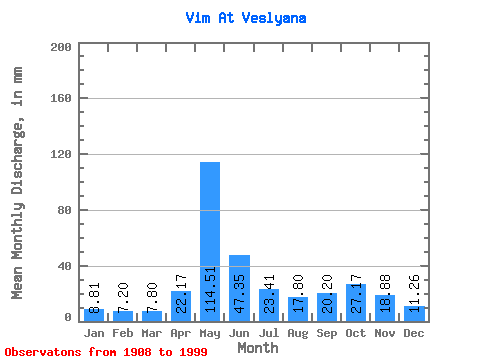
| Statistic | Jan | Feb | Mar | Apr | May | Jun | Jul | Aug | Sep | Oct | Nov | Dec | Annual |
|---|---|---|---|---|---|---|---|---|---|---|---|---|---|
| Mean | 8.81 | 7.26 | 7.80 | 22.17 | 114.49 | 47.35 | 23.41 | 17.80 | 20.20 | 27.16 | 18.88 | 11.26 | 325.70 |
| Standard Deviation | 1.52 | 1.21 | 1.25 | 24.09 | 34.19 | 21.63 | 10.13 | 8.89 | 10.42 | 11.61 | 7.67 | 2.92 | 50.56 |
| Min | 4.77 | 3.73 | 3.59 | 6.47 | 48.09 | 18.59 | 10.12 | 8.90 | 7.90 | 9.44 | 7.86 | 5.78 | 202.80 |
| Max | 12.73 | 9.70 | 10.57 | 119.29 | 196.29 | 117.11 | 61.97 | 60.01 | 70.84 | 69.97 | 41.93 | 20.89 | 452.83 |
| Coefficient of Variation | 0.17 | 0.17 | 0.16 | 1.09 | 0.30 | 0.46 | 0.43 | 0.50 | 0.52 | 0.43 | 0.41 | 0.26 | 0.15 |
 Return to R-Arctic Net Home Page