|
|
|||||||||||||||||
| Point ID: 7407 | Downloads | Plots | Site Data | Code: 70238 |
|
|
|||||||||||||||||
| Download | |
|---|---|
| Site Descriptor Information | Site Time Series Data |
| Link to all available data | |
| View: | Time Series | All |
| Units: | mm |
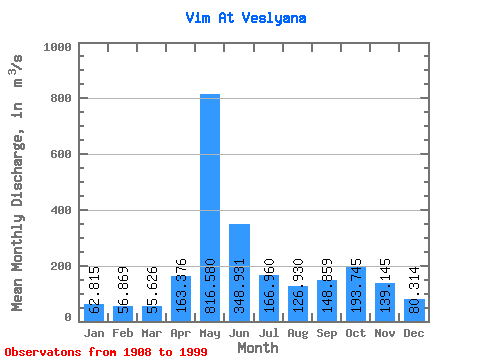
| Statistic | Jan | Feb | Mar | Apr | May | Jun | Jul | Aug | Sep | Oct | Nov | Dec | Annual |
|---|---|---|---|---|---|---|---|---|---|---|---|---|---|
| Mean | 62.81 | 56.87 | 55.63 | 163.38 | 816.58 | 348.93 | 166.96 | 126.93 | 148.86 | 193.75 | 139.15 | 80.31 | 197.12 |
| Standard Deviation | 10.85 | 9.47 | 8.92 | 177.55 | 243.84 | 159.37 | 72.27 | 63.39 | 76.76 | 82.83 | 56.54 | 20.82 | 30.60 |
| Min | 34.00 | 29.20 | 25.60 | 47.70 | 343.00 | 137.00 | 72.20 | 63.50 | 58.20 | 67.30 | 57.90 | 41.20 | 122.73 |
| Max | 90.80 | 75.90 | 75.40 | 879.00 | 1400.00 | 863.00 | 442.00 | 428.00 | 522.00 | 499.00 | 309.00 | 149.00 | 274.05 |
| Coefficient of Variation | 0.17 | 0.17 | 0.16 | 1.09 | 0.30 | 0.46 | 0.43 | 0.50 | 0.52 | 0.43 | 0.41 | 0.26 | 0.15 |
 Return to R-Arctic Net Home Page