|
|
|||||||||||||||||
| Point ID: 7386 | Downloads | Plots | Site Data | Code: 70177 |
|
|
|||||||||||||||||
| Download | |
|---|---|
| Site Descriptor Information | Site Time Series Data |
| Link to all available data | |
| View: | Time Series | All |
| Units: | m3/s |
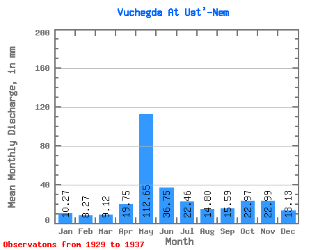
| Statistic | Jan | Feb | Mar | Apr | May | Jun | Jul | Aug | Sep | Oct | Nov | Dec | Annual |
|---|---|---|---|---|---|---|---|---|---|---|---|---|---|
| Mean | 10.27 | 8.35 | 9.12 | 19.75 | 112.63 | 36.75 | 22.46 | 14.80 | 15.59 | 22.96 | 22.99 | 13.13 | 314.76 |
| Standard Deviation | 1.66 | 1.31 | 1.30 | 5.65 | 32.84 | 12.60 | 14.98 | 5.71 | 5.55 | 5.50 | 5.01 | 3.22 | 45.35 |
| Min | 7.50 | 5.87 | 6.84 | 11.09 | 56.84 | 20.07 | 10.88 | 8.90 | 8.14 | 15.60 | 16.89 | 8.66 | 253.36 |
| Max | 13.27 | 10.22 | 11.21 | 26.59 | 160.51 | 60.37 | 53.73 | 25.92 | 23.24 | 31.10 | 32.44 | 19.87 | 375.48 |
| Coefficient of Variation | 0.16 | 0.16 | 0.14 | 0.29 | 0.29 | 0.34 | 0.67 | 0.39 | 0.36 | 0.24 | 0.22 | 0.24 | 0.14 |
 Return to R-Arctic Net Home Page