|
|
|||||||||||||||||
| Point ID: 7386 | Downloads | Plots | Site Data | Code: 70177 |
|
|
|||||||||||||||||
| Download | |
|---|---|
| Site Descriptor Information | Site Time Series Data |
| Link to all available data | |
| View: | Time Series | All |
| Units: | mm |
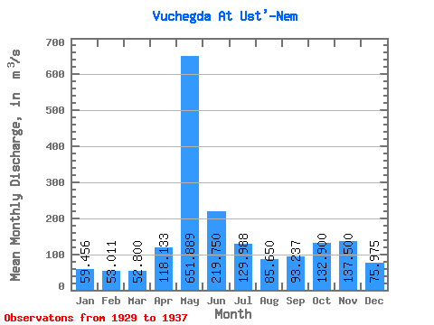
| Statistic | Jan | Feb | Mar | Apr | May | Jun | Jul | Aug | Sep | Oct | Nov | Dec | Annual |
|---|---|---|---|---|---|---|---|---|---|---|---|---|---|
| Mean | 59.46 | 53.01 | 52.80 | 118.13 | 651.89 | 219.75 | 129.99 | 85.65 | 93.24 | 132.90 | 137.50 | 75.97 | 154.59 |
| Standard Deviation | 9.62 | 8.32 | 7.51 | 33.80 | 190.08 | 75.36 | 86.70 | 33.06 | 33.18 | 31.83 | 29.97 | 18.63 | 22.27 |
| Min | 43.40 | 37.30 | 39.60 | 66.30 | 329.00 | 120.00 | 63.00 | 51.50 | 48.70 | 90.30 | 101.00 | 50.10 | 124.43 |
| Max | 76.80 | 64.90 | 64.90 | 159.00 | 929.00 | 361.00 | 311.00 | 150.00 | 139.00 | 180.00 | 194.00 | 115.00 | 184.41 |
| Coefficient of Variation | 0.16 | 0.16 | 0.14 | 0.29 | 0.29 | 0.34 | 0.67 | 0.39 | 0.36 | 0.24 | 0.22 | 0.24 | 0.14 |
 Return to R-Arctic Net Home Page