|
|
|||||||||||||||||
| Point ID: 7386 | Downloads | Plots | Site Data | Code: 70177 |
|
|
|||||||||||||||||
| Download | |
|---|---|
| Site Descriptor Information | Site Time Series Data |
| Link to all available data | |
|
|
| View: | Statistics | Time Series |
| Units: | mm |
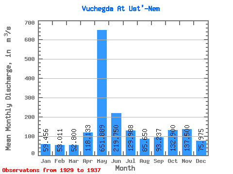
| Statistic | Jan | Feb | Mar | Apr | May | Jun | Jul | Aug | Sep | Oct | Nov | Dec | Annual |
|---|---|---|---|---|---|---|---|---|---|---|---|---|---|
| Mean | 59.46 | 53.01 | 52.80 | 118.13 | 651.89 | 219.75 | 129.99 | 85.65 | 93.24 | 132.90 | 137.50 | 75.97 | 154.59 |
| Standard Deviation | 9.62 | 8.32 | 7.51 | 33.80 | 190.08 | 75.36 | 86.70 | 33.06 | 33.18 | 31.83 | 29.97 | 18.63 | 22.27 |
| Min | 43.40 | 37.30 | 39.60 | 66.30 | 329.00 | 120.00 | 63.00 | 51.50 | 48.70 | 90.30 | 101.00 | 50.10 | 124.43 |
| Max | 76.80 | 64.90 | 64.90 | 159.00 | 929.00 | 361.00 | 311.00 | 150.00 | 139.00 | 180.00 | 194.00 | 115.00 | 184.41 |
| Coefficient of Variation | 0.16 | 0.16 | 0.14 | 0.29 | 0.29 | 0.34 | 0.67 | 0.39 | 0.36 | 0.24 | 0.22 | 0.24 | 0.14 |
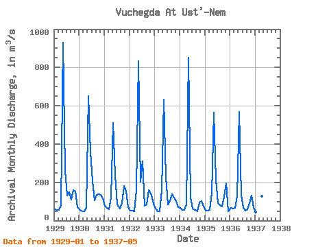
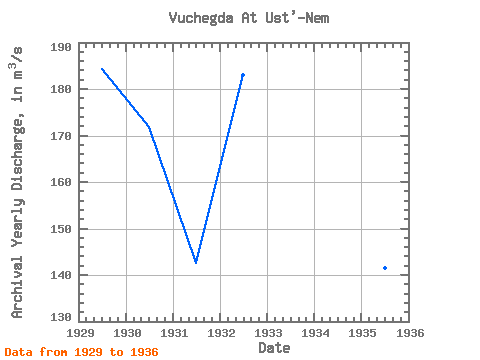
| Year | Jan | Feb | Mar | Apr | May | Jun | Jul | Aug | Sep | Oct | Nov | Dec | Annual | 1929 | 60.50 | 55.70 | 55.00 | 78.90 | 929.00 | 262.00 | 130.00 | 150.00 | 110.00 | 158.00 | 153.00 | 70.80 | 184.41 | 1930 | 55.60 | 47.70 | 46.90 | 66.30 | 649.00 | 361.00 | 207.00 | 106.00 | 136.00 | 139.00 | 133.00 | 115.00 | 171.88 | 1931 | 76.80 | 64.90 | 59.30 | 120.00 | 510.00 | 238.00 | 83.40 | 61.70 | 92.60 | 180.00 | 153.00 | 71.00 | 142.56 | 1932 | 53.00 | 50.30 | 49.40 | 159.00 | 832.00 | 202.00 | 311.00 | 77.80 | 85.50 | 158.00 | 131.00 | 86.40 | 182.95 | 1933 | 62.00 | 49.30 | 48.50 | 157.00 | 632.00 | 226.00 | 85.70 | 103.00 | 139.00 | 121.00 | 101.00 | 70.10 | 149.55 | 1934 | 65.30 | 56.60 | 55.10 | 86.00 | 853.00 | 120.00 | 63.00 | 54.50 | 48.70 | 93.90 | 103.00 | 74.80 | 139.49 | 1935 | 52.80 | 52.50 | 56.50 | 141.00 | 566.00 | 215.00 | 91.80 | 80.70 | 73.70 | 123.00 | 194.00 | 50.10 | 141.43 | 1936 | 65.70 | 62.80 | 64.90 | 127.00 | 567.00 | 134.00 | 68.00 | 51.50 | 60.40 | 90.30 | 132.00 | 69.60 | 124.43 | 1937 | 43.40 | 37.30 | 39.60 | 128.00 | 329.00 |
|---|
 Return to R-Arctic Net Home Page