|
|
|||||||||||||||||
| Point ID: 7366 | Downloads | Plots | Site Data | Code: 70146 |
|
|
|||||||||||||||||
| Download | |
|---|---|
| Site Descriptor Information | Site Time Series Data |
| Link to all available data | |
| View: | Time Series | All |
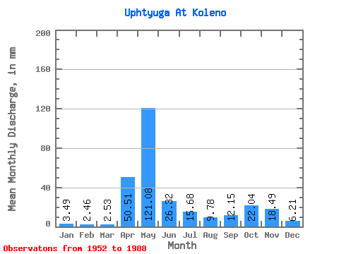
| Units: | m3/s |
| Statistic | Jan | Feb | Mar | Apr | May | Jun | Jul | Aug | Sep | Oct | Nov | Dec | Annual |
|---|---|---|---|---|---|---|---|---|---|---|---|---|---|
| Mean | 3.49 | 2.48 | 2.53 | 50.51 | 121.06 | 26.32 | 15.68 | 9.77 | 12.15 | 22.04 | 18.49 | 6.21 | 287.34 |
| Standard Deviation | 1.61 | 1.08 | 1.12 | 41.31 | 54.61 | 18.44 | 14.80 | 11.26 | 13.18 | 17.71 | 14.00 | 3.77 | 68.71 |
| Min | 1.59 | 0.97 | 1.23 | 4.17 | 31.21 | 5.14 | 3.09 | 2.39 | 2.69 | 3.43 | 2.55 | 2.09 | 166.29 |
| Max | 8.78 | 5.52 | 6.99 | 141.68 | 245.10 | 101.70 | 57.87 | 62.07 | 64.14 | 81.70 | 68.53 | 19.63 | 413.44 |
| Coefficient of Variation | 0.46 | 0.43 | 0.44 | 0.82 | 0.45 | 0.70 | 0.94 | 1.15 | 1.08 | 0.80 | 0.76 | 0.61 | 0.24 |
 Return to R-Arctic Net Home Page