|
|
|||||||||||||||||
| Point ID: 7366 | Downloads | Plots | Site Data | Code: 70146 |
|
|
|||||||||||||||||
| Download | |
|---|---|
| Site Descriptor Information | Site Time Series Data |
| Link to all available data | |
| View: | Time Series | All |
| Units: | mm |
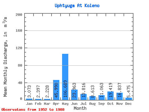
| Statistic | Jan | Feb | Mar | Apr | May | Jun | Jul | Aug | Sep | Oct | Nov | Dec | Annual |
|---|---|---|---|---|---|---|---|---|---|---|---|---|---|
| Mean | 3.07 | 2.40 | 2.23 | 45.99 | 106.69 | 23.96 | 13.82 | 8.61 | 11.06 | 19.42 | 16.84 | 5.47 | 21.49 |
| Standard Deviation | 1.42 | 1.04 | 0.99 | 37.61 | 48.13 | 16.79 | 13.05 | 9.93 | 12.00 | 15.61 | 12.74 | 3.32 | 5.14 |
| Min | 1.40 | 0.94 | 1.08 | 3.80 | 27.50 | 4.68 | 2.72 | 2.11 | 2.45 | 3.02 | 2.32 | 1.84 | 12.44 |
| Max | 7.74 | 5.34 | 6.16 | 129.00 | 216.00 | 92.60 | 51.00 | 54.70 | 58.40 | 72.00 | 62.40 | 17.30 | 30.92 |
| Coefficient of Variation | 0.46 | 0.43 | 0.44 | 0.82 | 0.45 | 0.70 | 0.94 | 1.15 | 1.08 | 0.80 | 0.76 | 0.61 | 0.24 |
 Return to R-Arctic Net Home Page