|
|
|||||||||||||||||
| Point ID: 728 | Downloads | Plots | Site Data | Code: 07DD003 |
|
|
|||||||||||||||||
| Download | |
|---|---|
| Site Descriptor Information | Site Time Series Data |
| Link to all available data | |
|
|
| View: | Statistics | Time Series |
| Units: | mm |
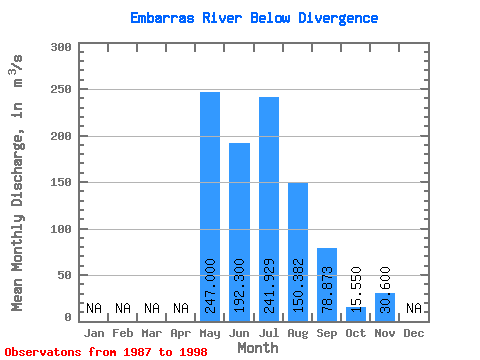
| Statistic | Jan | Feb | Mar | Apr | May | Jun | Jul | Aug | Sep | Oct | Nov | Dec | Annual |
|---|---|---|---|---|---|---|---|---|---|---|---|---|---|
| Mean | 247.00 | 192.30 | 241.93 | 150.38 | 78.87 | 15.55 | 30.60 | ||||||
| Standard Deviation | 94.24 | 143.22 | 96.80 | 59.03 | 7.85 | ||||||||
| Min | 247.00 | 86.80 | 56.50 | 45.50 | 17.30 | 10.00 | 30.60 | ||||||
| Max | 247.00 | 351.00 | 490.00 | 360.00 | 193.00 | 21.10 | 30.60 | ||||||
| Coefficient of Variation | 0.49 | 0.59 | 0.64 | 0.75 | 0.51 |
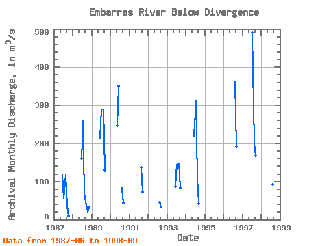
| Year | Jan | Feb | Mar | Apr | May | Jun | Jul | Aug | Sep | Oct | Nov | Dec | Annual | 1987 | 117.00 | 56.50 | 118.00 | 35.80 | 10.00 | 1988 | 161.00 | 259.00 | 71.30 | 48.20 | 21.10 | 30.60 | 1989 | 216.00 | 289.00 | 289.00 | 130.00 | 1990 | 247.00 | 351.00 | 81.80 | 44.70 | 1991 | 137.00 | 72.50 | 1992 | 45.50 | 32.90 | 1993 | 86.80 | 145.00 | 148.00 | 82.90 | 1994 | 222.00 | 313.00 | 111.00 | 42.30 | 1996 | 360.00 | 193.00 | 1997 | 490.00 | 200.00 | 168.00 | 1998 | 141.00 | 92.60 | 17.30 |
|---|
 Return to R-Arctic Net Home Page