|
|
|||||||||||||||||
| Point ID: 728 | Downloads | Plots | Site Data | Code: 07DD003 |
|
|
|||||||||||||||||
| Download | |
|---|---|
| Site Descriptor Information | Site Time Series Data |
| Link to all available data | |
| View: | Time Series | All |
| Units: | mm |
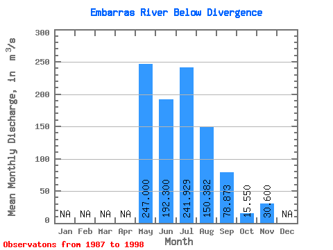
| Statistic | Jan | Feb | Mar | Apr | May | Jun | Jul | Aug | Sep | Oct | Nov | Dec | Annual |
|---|---|---|---|---|---|---|---|---|---|---|---|---|---|
| Mean | 247.00 | 192.30 | 241.93 | 150.38 | 78.87 | 15.55 | 30.60 | ||||||
| Standard Deviation | 94.24 | 143.22 | 96.80 | 59.03 | 7.85 | ||||||||
| Min | 247.00 | 86.80 | 56.50 | 45.50 | 17.30 | 10.00 | 30.60 | ||||||
| Max | 247.00 | 351.00 | 490.00 | 360.00 | 193.00 | 21.10 | 30.60 | ||||||
| Coefficient of Variation | 0.49 | 0.59 | 0.64 | 0.75 | 0.51 |
 Return to R-Arctic Net Home Page