|
|
|||||||||||||||||
| Point ID: 725 | Downloads | Plots | Site Data | Code: 07DC002 |
|
|
|||||||||||||||||
| Download | |
|---|---|
| Site Descriptor Information | Site Time Series Data |
| Link to all available data | |
|
|
| View: | Statistics | Time Series |
| Units: | mm |
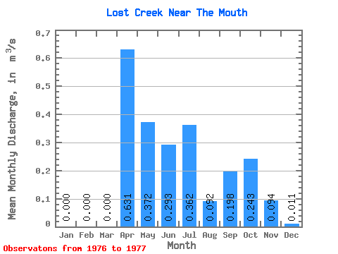
| Statistic | Jan | Feb | Mar | Apr | May | Jun | Jul | Aug | Sep | Oct | Nov | Dec | Annual |
|---|---|---|---|---|---|---|---|---|---|---|---|---|---|
| Mean | 0.00 | 0.00 | 0.00 | 0.63 | 0.37 | 0.29 | 0.36 | 0.09 | 0.20 | 0.24 | 0.09 | 0.01 | 0.17 |
| Standard Deviation | 0.01 | 0.14 | 0.14 | 0.06 | 0.01 | ||||||||
| Min | 0.00 | 0.00 | 0.00 | 0.63 | 0.37 | 0.29 | 0.36 | 0.09 | 0.10 | 0.15 | 0.05 | 0.01 | 0.17 |
| Max | 0.00 | 0.00 | 0.00 | 0.63 | 0.37 | 0.29 | 0.36 | 0.10 | 0.29 | 0.34 | 0.13 | 0.02 | 0.17 |
| Coefficient of Variation | 0.06 | 0.69 | 0.57 | 0.60 | 0.64 |
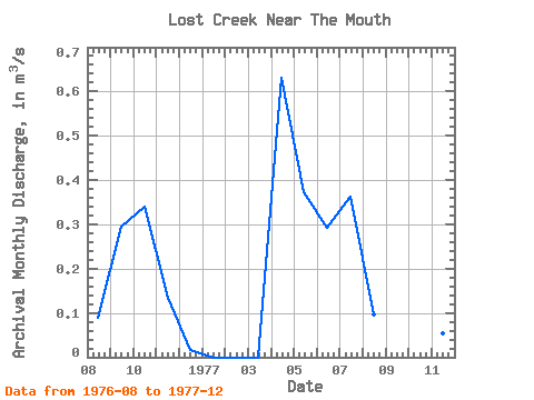
| Year | Jan | Feb | Mar | Apr | May | Jun | Jul | Aug | Sep | Oct | Nov | Dec | Annual | 1976 | 0.09 | 0.29 | 0.34 | 0.13 | 0.02 | 1977 | 0.00 | 0.00 | 0.00 | 0.63 | 0.37 | 0.29 | 0.36 | 0.10 | 0.10 | 0.15 | 0.05 | 0.01 | 0.17 |
|---|
 Return to R-Arctic Net Home Page