|
|
|||||||||||||||||
| Point ID: 725 | Downloads | Plots | Site Data | Code: 07DC002 |
|
|
|||||||||||||||||
| Download | |
|---|---|
| Site Descriptor Information | Site Time Series Data |
| Link to all available data | |
|
|
| View: | Statistics | Time Series |
| Units: | m3/s |
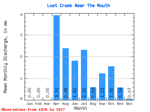
| Statistic | Jan | Feb | Mar | Apr | May | Jun | Jul | Aug | Sep | Oct | Nov | Dec | Annual |
|---|---|---|---|---|---|---|---|---|---|---|---|---|---|
| Mean | 0.00 | 0.00 | 0.00 | 3.91 | 2.38 | 1.82 | 2.32 | 0.59 | 1.23 | 1.56 | 0.58 | 0.07 | 12.97 |
| Standard Deviation | 0.04 | 0.84 | 0.88 | 0.35 | 0.04 | ||||||||
| Min | 0.00 | 0.00 | 0.00 | 3.91 | 2.38 | 1.82 | 2.32 | 0.56 | 0.63 | 0.94 | 0.34 | 0.04 | 12.97 |
| Max | 0.00 | 0.00 | 0.00 | 3.91 | 2.38 | 1.82 | 2.32 | 0.61 | 1.82 | 2.19 | 0.82 | 0.10 | 12.97 |
| Coefficient of Variation | 0.06 | 0.69 | 0.57 | 0.60 | 0.64 |
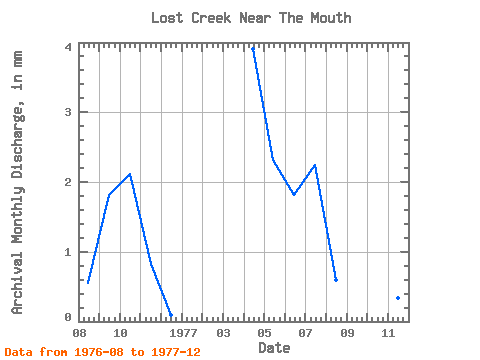
| Year | Jan | Feb | Mar | Apr | May | Jun | Jul | Aug | Sep | Oct | Nov | Dec | Annual | 1976 | 0.56 | 1.82 | 2.19 | 0.82 | 0.10 | 1977 | 0.00 | 0.00 | 0.00 | 3.91 | 2.38 | 1.82 | 2.32 | 0.61 | 0.63 | 0.94 | 0.34 | 0.04 | 12.97 |
|---|
 Return to R-Arctic Net Home Page