|
|
|||||||||||||||||
| Point ID: 722 | Downloads | Plots | Site Data | Code: 07DB004 |
|
|
|||||||||||||||||
| Download | |
|---|---|
| Site Descriptor Information | Site Time Series Data |
| Link to all available data | |
|
|
| View: | Statistics | Time Series |
| Units: | mm |
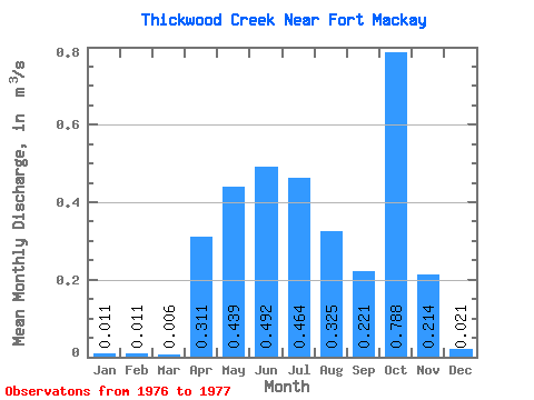
| Statistic | Jan | Feb | Mar | Apr | May | Jun | Jul | Aug | Sep | Oct | Nov | Dec | Annual |
|---|---|---|---|---|---|---|---|---|---|---|---|---|---|
| Mean | 0.01 | 0.01 | 0.01 | 0.31 | 0.44 | 0.49 | 0.46 | 0.33 | 0.22 | 0.79 | 0.21 | 0.02 | 0.27 |
| Standard Deviation | 0.42 | 0.15 | 0.54 | 0.10 | 0.00 | ||||||||
| Min | 0.01 | 0.01 | 0.01 | 0.31 | 0.44 | 0.20 | 0.36 | 0.33 | 0.22 | 0.41 | 0.15 | 0.02 | 0.27 |
| Max | 0.01 | 0.01 | 0.01 | 0.31 | 0.44 | 0.79 | 0.57 | 0.33 | 0.22 | 1.17 | 0.28 | 0.02 | 0.27 |
| Coefficient of Variation | 0.85 | 0.32 | 0.68 | 0.44 | 0.14 |
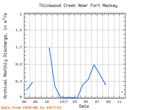
| Year | Jan | Feb | Mar | Apr | May | Jun | Jul | Aug | Sep | Oct | Nov | Dec | Annual | 1976 | 0.20 | 0.36 | 1.17 | 0.28 | 0.02 | 1977 | 0.01 | 0.01 | 0.01 | 0.31 | 0.44 | 0.79 | 0.57 | 0.33 | 0.22 | 0.41 | 0.15 | 0.02 | 0.27 |
|---|
 Return to R-Arctic Net Home Page