|
|
|||||||||||||||||
| Point ID: 722 | Downloads | Plots | Site Data | Code: 07DB004 |
|
|
|||||||||||||||||
| Download | |
|---|---|
| Site Descriptor Information | Site Time Series Data |
| Link to all available data | |
|
|
| View: | Statistics | Time Series |
| Units: | m3/s |
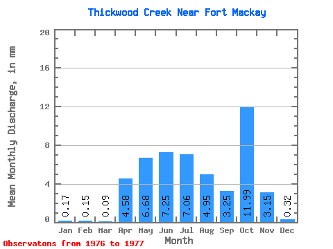
| Statistic | Jan | Feb | Mar | Apr | May | Jun | Jul | Aug | Sep | Oct | Nov | Dec | Annual |
|---|---|---|---|---|---|---|---|---|---|---|---|---|---|
| Mean | 0.17 | 0.15 | 0.09 | 4.58 | 6.68 | 7.25 | 7.06 | 4.95 | 3.25 | 12.00 | 3.15 | 0.32 | 48.62 |
| Standard Deviation | 6.16 | 2.26 | 8.21 | 1.40 | 0.04 | ||||||||
| Min | 0.17 | 0.15 | 0.09 | 4.58 | 6.68 | 2.90 | 5.46 | 4.95 | 3.25 | 6.19 | 2.17 | 0.29 | 48.62 |
| Max | 0.17 | 0.15 | 0.09 | 4.58 | 6.68 | 11.61 | 8.66 | 4.95 | 3.25 | 17.80 | 4.14 | 0.35 | 48.62 |
| Coefficient of Variation | 0.85 | 0.32 | 0.68 | 0.44 | 0.14 |
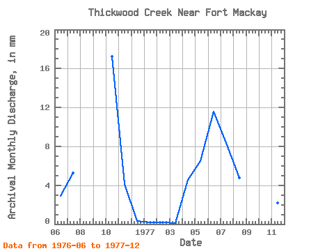
| Year | Jan | Feb | Mar | Apr | May | Jun | Jul | Aug | Sep | Oct | Nov | Dec | Annual | 1976 | 2.90 | 5.46 | 17.80 | 4.14 | 0.35 | 1977 | 0.17 | 0.15 | 0.09 | 4.58 | 6.68 | 11.61 | 8.66 | 4.95 | 3.25 | 6.19 | 2.17 | 0.29 | 48.62 |
|---|
 Return to R-Arctic Net Home Page