|
|
|||||||||||||||||
| Point ID: 7219 | Downloads | Plots | Site Data | Code: 12310 |
|
|
|||||||||||||||||
| Download | |
|---|---|
| Site Descriptor Information | Site Time Series Data |
| Link to all available data | |
| View: | Time Series | All |
| Units: | m3/s |
| Statistic | Jan | Feb | Mar | Apr | May | Jun | Jul | Aug | Sep | Oct | Nov | Dec | Annual |
|---|---|---|---|---|---|---|---|---|---|---|---|---|---|
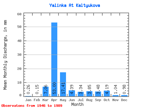
| Mean | 0.27 | 0.16 | 7.07 | 52.98 | 17.43 | 4.40 | 3.32 | 3.84 | 3.47 | 4.19 | 1.04 | 0.97 | 78.19 |
| Standard Deviation | 0.43 | 0.34 | 12.05 | 31.01 | 16.98 | 4.91 | 6.37 | 5.97 | 5.92 | 7.91 | 1.19 | 1.88 | 44.63 |
| Min | 0.00 | 0.00 | 0.00 | 7.04 | 1.37 | 0.00 | 0.00 | 0.00 | 0.00 | 0.00 | 0.00 | 0.00 | 49.11 |
| Max | 0.98 | 0.86 | 48.77 | 134.98 | 89.84 | 23.60 | 31.23 | 21.82 | 32.71 | 46.63 | 6.21 | 7.27 | 129.57 |
| Coefficient of Variation | 1.58 | 2.21 | 1.71 | 0.58 | 0.97 | 1.11 | 1.92 | 1.55 | 1.71 | 1.89 | 1.15 | 1.93 | 0.57 |
 Return to R-Arctic Net Home Page