|
|
|||||||||||||||||
| Point ID: 7219 | Downloads | Plots | Site Data | Code: 12310 |
|
|
|||||||||||||||||
| Download | |
|---|---|
| Site Descriptor Information | Site Time Series Data |
| Link to all available data | |
| View: | Time Series | All |
| Units: | mm |
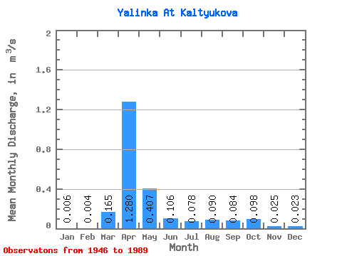
| Statistic | Jan | Feb | Mar | Apr | May | Jun | Jul | Aug | Sep | Oct | Nov | Dec | Annual |
|---|---|---|---|---|---|---|---|---|---|---|---|---|---|
| Mean | 0.01 | 0.00 | 0.17 | 1.28 | 0.41 | 0.11 | 0.08 | 0.09 | 0.08 | 0.10 | 0.03 | 0.02 | 0.15 |
| Standard Deviation | 0.01 | 0.01 | 0.28 | 0.75 | 0.40 | 0.12 | 0.15 | 0.14 | 0.14 | 0.18 | 0.03 | 0.04 | 0.09 |
| Min | 0.00 | 0.00 | 0.00 | 0.17 | 0.03 | 0.00 | 0.00 | 0.00 | 0.00 | 0.00 | 0.00 | 0.00 | 0.10 |
| Max | 0.02 | 0.02 | 1.14 | 3.26 | 2.10 | 0.57 | 0.73 | 0.51 | 0.79 | 1.09 | 0.15 | 0.17 | 0.26 |
| Coefficient of Variation | 1.58 | 2.21 | 1.71 | 0.58 | 0.97 | 1.11 | 1.92 | 1.55 | 1.71 | 1.89 | 1.15 | 1.93 | 0.57 |
 Return to R-Arctic Net Home Page