|
|
|||||||||||||||||
| Point ID: 7196 | Downloads | Plots | Site Data | Code: 12188 |
|
|
|||||||||||||||||
| Download | |
|---|---|
| Site Descriptor Information | Site Time Series Data |
| Link to all available data | |
|
|
| View: | Statistics | Time Series |
| Units: | mm |
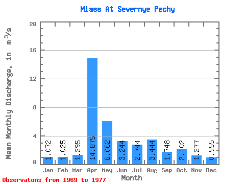
| Statistic | Jan | Feb | Mar | Apr | May | Jun | Jul | Aug | Sep | Oct | Nov | Dec | Annual |
|---|---|---|---|---|---|---|---|---|---|---|---|---|---|
| Mean | 1.07 | 1.02 | 1.29 | 14.88 | 6.06 | 3.24 | 2.74 | 3.44 | 1.75 | 2.10 | 1.28 | 0.95 | 5.92 |
| Standard Deviation | 0.73 | 0.55 | 0.87 | 19.13 | 7.38 | 1.73 | 1.93 | 2.69 | 1.24 | 1.75 | 0.83 | 0.57 | |
| Min | 0.43 | 0.40 | 0.40 | 1.35 | 0.48 | 0.33 | 0.34 | 0.34 | 0.39 | 0.35 | 0.35 | 0.41 | 5.92 |
| Max | 2.08 | 1.75 | 2.49 | 28.40 | 17.20 | 4.97 | 4.96 | 6.03 | 3.57 | 4.73 | 2.42 | 1.87 | 5.92 |
| Coefficient of Variation | 0.69 | 0.54 | 0.67 | 1.29 | 1.22 | 0.53 | 0.70 | 0.78 | 0.71 | 0.83 | 0.65 | 0.60 |
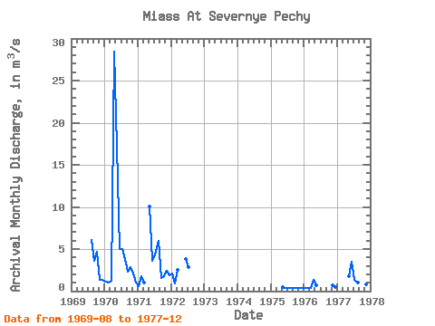
| Year | Jan | Feb | Mar | Apr | May | Jun | Jul | Aug | Sep | Oct | Nov | Dec | Annual | 1969 | 6.03 | 3.57 | 4.73 | 1.38 | 1.34 | 1970 | 1.14 | 0.99 | 1.22 | 28.40 | 17.20 | 4.97 | 4.96 | 3.85 | 2.30 | 2.86 | 2.08 | 1.03 | 5.92 | 1971 | 0.64 | 1.75 | 1.07 | 10.10 | 3.58 | 4.22 | 6.00 | 1.52 | 1.75 | 2.42 | 1.87 | 1972 | 2.08 | 0.96 | 2.49 | 3.85 | 2.85 | 1975 | 0.48 | 0.33 | 0.34 | 0.34 | 0.39 | 0.35 | 0.35 | 0.41 | 1976 | 0.43 | 0.40 | 0.40 | 1.35 | 0.74 | 0.66 | 0.45 | 1977 | 1.79 | 3.49 | 1.35 | 1.00 | 0.96 | 0.82 | 0.77 | 0.63 |
|---|
 Return to R-Arctic Net Home Page