|
|
|||||||||||||||||
| Point ID: 7196 | Downloads | Plots | Site Data | Code: 12188 |
|
|
|||||||||||||||||
| Download | |
|---|---|
| Site Descriptor Information | Site Time Series Data |
| Link to all available data | |
|
|
| View: | Statistics | Time Series |
| Units: | m3/s |
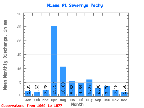
| Statistic | Jan | Feb | Mar | Apr | May | Jun | Jul | Aug | Sep | Oct | Nov | Dec | Annual |
|---|---|---|---|---|---|---|---|---|---|---|---|---|---|
| Mean | 1.89 | 1.65 | 2.28 | 25.37 | 10.68 | 5.53 | 4.83 | 6.07 | 2.98 | 3.70 | 2.18 | 1.68 | 122.85 |
| Standard Deviation | 1.29 | 0.89 | 1.54 | 32.62 | 13.01 | 2.96 | 3.39 | 4.74 | 2.11 | 3.09 | 1.42 | 1.01 | |
| Min | 0.76 | 0.64 | 0.70 | 2.30 | 0.85 | 0.56 | 0.60 | 0.60 | 0.67 | 0.62 | 0.60 | 0.72 | 122.85 |
| Max | 3.67 | 2.81 | 4.39 | 48.43 | 30.30 | 8.47 | 8.74 | 10.62 | 6.09 | 8.33 | 4.13 | 3.29 | 122.85 |
| Coefficient of Variation | 0.69 | 0.54 | 0.67 | 1.29 | 1.22 | 0.53 | 0.70 | 0.78 | 0.71 | 0.83 | 0.65 | 0.60 |
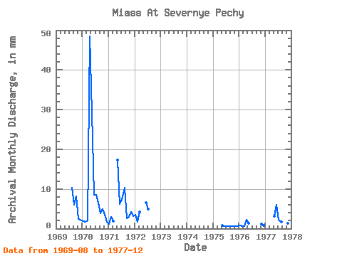
| Year | Jan | Feb | Mar | Apr | May | Jun | Jul | Aug | Sep | Oct | Nov | Dec | Annual | 1969 | 10.62 | 6.09 | 8.33 | 2.35 | 2.36 | 1970 | 2.01 | 1.59 | 2.15 | 48.43 | 30.30 | 8.47 | 8.74 | 6.78 | 3.92 | 5.04 | 3.55 | 1.81 | 122.85 | 1971 | 1.13 | 2.81 | 1.89 | 17.80 | 6.11 | 7.43 | 10.57 | 2.59 | 3.08 | 4.13 | 3.29 | 1972 | 3.67 | 1.54 | 4.39 | 6.56 | 5.02 | 1975 | 0.85 | 0.56 | 0.60 | 0.60 | 0.67 | 0.62 | 0.60 | 0.72 | 1976 | 0.76 | 0.64 | 0.70 | 2.30 | 1.30 | 1.12 | 0.79 | 1977 | 3.15 | 5.95 | 2.38 | 1.76 | 1.64 | 1.45 | 1.31 | 1.11 |
|---|
 Return to R-Arctic Net Home Page