|
|
|||||||||||||||||
| Point ID: 7155 | Downloads | Plots | Site Data | Code: 12022 |
|
|
|||||||||||||||||
| Download | |
|---|---|
| Site Descriptor Information | Site Time Series Data |
| Link to all available data | |
|
|
| View: | Statistics | Time Series |
| Units: | mm |
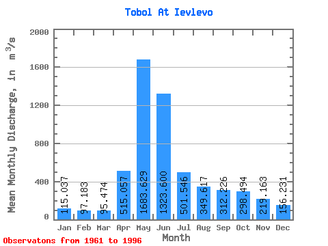
| Statistic | Jan | Feb | Mar | Apr | May | Jun | Jul | Aug | Sep | Oct | Nov | Dec | Annual |
|---|---|---|---|---|---|---|---|---|---|---|---|---|---|
| Mean | 115.04 | 97.18 | 95.47 | 515.06 | 1683.63 | 1323.60 | 501.55 | 349.62 | 312.23 | 298.49 | 219.16 | 156.23 | 472.27 |
| Standard Deviation | 46.02 | 33.81 | 33.60 | 290.82 | 980.54 | 1222.97 | 359.78 | 317.43 | 297.48 | 253.15 | 140.57 | 80.31 | 245.37 |
| Min | 48.80 | 43.50 | 47.80 | 144.00 | 327.00 | 104.00 | 78.10 | 58.80 | 47.40 | 45.80 | 53.60 | 58.50 | 122.25 |
| Max | 224.00 | 184.00 | 215.00 | 1560.00 | 4660.00 | 6790.00 | 1830.00 | 1400.00 | 1550.00 | 1100.00 | 532.00 | 378.00 | 1050.00 |
| Coefficient of Variation | 0.40 | 0.35 | 0.35 | 0.56 | 0.58 | 0.92 | 0.72 | 0.91 | 0.95 | 0.85 | 0.64 | 0.51 | 0.52 |
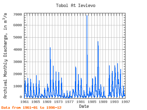
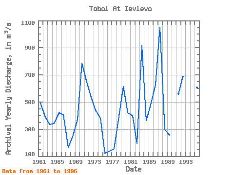
| Year | Jan | Feb | Mar | Apr | May | Jun | Jul | Aug | Sep | Oct | Nov | Dec | Annual | 1961 | 71.40 | 71.80 | 73.50 | 868.00 | 1470.00 | 1170.00 | 691.00 | 444.00 | 337.00 | 331.00 | 253.00 | 150.00 | 494.23 | 1962 | 119.00 | 105.00 | 110.00 | 702.00 | 1650.00 | 796.00 | 359.00 | 204.00 | 192.00 | 166.00 | 155.00 | 122.00 | 390.00 | 1963 | 89.90 | 81.40 | 82.60 | 338.00 | 1580.00 | 1010.00 | 301.00 | 123.00 | 111.00 | 120.00 | 92.70 | 93.10 | 335.23 | 1964 | 80.10 | 69.80 | 60.70 | 144.00 | 1180.00 | 755.00 | 599.00 | 319.00 | 313.00 | 248.00 | 204.00 | 147.00 | 343.30 | 1965 | 112.00 | 99.00 | 98.90 | 502.00 | 1860.00 | 1420.00 | 430.00 | 133.00 | 111.00 | 107.00 | 93.30 | 84.90 | 420.93 | 1966 | 81.50 | 71.80 | 64.90 | 847.00 | 1440.00 | 1080.00 | 577.00 | 200.00 | 164.00 | 149.00 | 99.30 | 84.80 | 404.94 | 1967 | 52.90 | 50.40 | 56.40 | 338.00 | 327.00 | 211.00 | 159.00 | 232.00 | 207.00 | 140.00 | 121.00 | 89.70 | 165.37 | 1968 | 69.10 | 63.10 | 72.10 | 520.00 | 835.00 | 527.00 | 277.00 | 228.00 | 109.00 | 94.50 | 86.70 | 75.50 | 246.42 | 1969 | 61.20 | 43.50 | 51.00 | 183.00 | 1160.00 | 726.00 | 523.00 | 842.00 | 350.00 | 196.00 | 163.00 | 153.00 | 370.98 | 1970 | 99.10 | 86.20 | 88.10 | 888.00 | 4160.00 | 2210.00 | 767.00 | 221.00 | 396.00 | 175.00 | 191.00 | 175.00 | 788.03 | 1971 | 133.00 | 122.00 | 108.00 | 421.00 | 2640.00 | 1760.00 | 793.00 | 757.00 | 483.00 | 230.00 | 233.00 | 238.00 | 659.83 | 1972 | 166.00 | 125.00 | 113.00 | 681.00 | 2170.00 | 1060.00 | 822.00 | 407.00 | 209.00 | 274.00 | 221.00 | 192.00 | 536.67 | 1973 | 149.00 | 110.00 | 103.00 | 698.00 | 2120.00 | 770.00 | 200.00 | 205.00 | 188.00 | 271.00 | 268.00 | 175.00 | 438.08 | 1974 | 110.00 | 85.40 | 84.30 | 732.00 | 1670.00 | 867.00 | 473.00 | 166.00 | 119.00 | 109.00 | 92.30 | 78.40 | 382.20 | 1975 | 59.40 | 61.80 | 66.50 | 404.00 | 349.00 | 160.00 | 78.10 | 58.80 | 62.20 | 55.10 | 53.60 | 58.50 | 122.25 | 1976 | 54.60 | 54.60 | 59.70 | 265.00 | 624.00 | 226.00 | 110.00 | 60.70 | 47.40 | 45.80 | 60.80 | 60.20 | 139.07 | 1977 | 48.80 | 46.40 | 47.80 | 433.00 | 590.00 | 104.00 | 100.00 | 103.00 | 129.00 | 116.00 | 90.40 | 72.60 | 156.75 | 1978 | 51.70 | 50.30 | 51.10 | 289.00 | 659.00 | 748.00 | 514.00 | 690.00 | 387.00 | 464.00 | 301.00 | 250.00 | 371.26 | 1979 | 136.00 | 112.00 | 116.00 | 166.00 | 2560.00 | 2400.00 | 703.00 | 288.00 | 259.00 | 223.00 | 218.00 | 176.00 | 613.08 | 1980 | 124.00 | 81.50 | 76.80 | 374.00 | 1950.00 | 944.00 | 339.00 | 255.00 | 291.00 | 253.00 | 192.00 | 160.00 | 420.02 | 1981 | 131.00 | 112.00 | 105.00 | 436.00 | 1650.00 | 1400.00 | 349.00 | 143.00 | 112.00 | 150.00 | 111.00 | 91.10 | 399.18 | 1982 | 76.10 | 71.00 | 71.30 | 280.00 | 652.00 | 406.00 | 209.00 | 96.10 | 76.30 | 96.90 | 167.00 | 130.00 | 194.31 | 1983 | 106.00 | 94.90 | 92.50 | 902.00 | 1410.00 | 6790.00 | 313.00 | 203.00 | 270.00 | 353.00 | 262.00 | 188.00 | 915.37 | 1984 | 132.00 | 107.00 | 103.00 | 255.00 | 857.00 | 799.00 | 239.00 | 165.00 | 289.00 | 506.00 | 522.00 | 378.00 | 362.67 | 1985 | 178.00 | 123.00 | 115.00 | 484.00 | 1610.00 | 1530.00 | 638.00 | 422.00 | 203.00 | 159.00 | 151.00 | 120.00 | 477.75 | 1986 | 104.00 | 105.00 | 103.00 | 499.00 | 1780.00 | 1600.00 | 696.00 | 559.00 | 649.00 | 579.00 | 532.00 | 358.00 | 630.33 | 1987 | 169.00 | 130.00 | 116.00 | 451.00 | 4660.00 | 3950.00 | 1150.00 | 272.00 | 261.00 | 736.00 | 468.00 | 237.00 | 1050.00 | 1988 | 157.00 | 129.00 | 105.00 | 481.00 | 1120.00 | 711.00 | 202.00 | 126.00 | 161.00 | 148.00 | 93.60 | 98.90 | 294.38 | 1989 | 98.50 | 88.10 | 98.50 | 196.00 | 874.00 | 926.00 | 267.00 | 122.00 | 117.00 | 126.00 | 107.00 | 75.40 | 257.96 | 1991 | 224.00 | 158.00 | 159.00 | 564.00 | 2670.00 | 1130.00 | 187.00 | 276.00 | 493.00 | 494.00 | 215.00 | 166.00 | 561.33 | 1992 | 139.00 | 131.00 | 137.00 | 358.00 | 1860.00 | 2210.00 | 559.00 | 753.00 | 916.00 | 519.00 | 422.00 | 223.00 | 685.58 | 1993 | 171.00 | 150.00 | 130.00 | 761.00 | 2660.00 | 2350.00 | 1830.00 | 1240.00 | 887.00 | 1100.00 | 512.00 | 246.00 | 1003.08 | 1994 | 147.00 | 130.00 | 118.00 | 818.00 | 2840.00 | 1450.00 | 1200.00 | 1400.00 | 1550.00 | 1010.00 | 469.00 | 277.00 | 950.75 | 1995 | 217.00 | 184.00 | 215.00 | 1560.00 | 2360.00 | 1130.00 | 521.00 | 316.00 | 289.00 | 195.00 | 182.00 | 131.00 | 608.33 | 1996 | 108.00 | 97.40 | 88.90 | 189.00 | 930.00 | 1000.00 | 379.00 | 207.00 | 190.00 | 508.00 | 268.00 | 113.00 | 339.86 |
|---|
 Return to R-Arctic Net Home Page