|
|
|||||||||||||||||
| Point ID: 714 | Downloads | Plots | Site Data | Code: 07DA015 |
|
|
|||||||||||||||||
| Download | |
|---|---|
| Site Descriptor Information | Site Time Series Data |
| Link to all available data | |
|
|
| View: | Statistics | Time Series |
| Units: | mm |
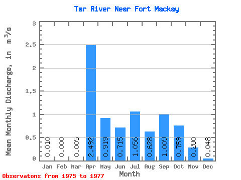
| Statistic | Jan | Feb | Mar | Apr | May | Jun | Jul | Aug | Sep | Oct | Nov | Dec | Annual |
|---|---|---|---|---|---|---|---|---|---|---|---|---|---|
| Mean | 0.01 | 0.00 | 0.01 | 2.49 | 0.92 | 0.71 | 1.06 | 0.63 | 1.01 | 0.76 | 0.28 | 0.05 | 0.49 |
| Standard Deviation | 0.01 | 0.00 | 0.01 | 2.43 | 0.03 | 0.15 | 0.49 | 0.68 | 0.13 | 0.19 | 0.04 | ||
| Min | 0.00 | 0.00 | 0.00 | 0.77 | 0.90 | 0.61 | 0.71 | 0.63 | 0.53 | 0.66 | 0.15 | 0.01 | 0.49 |
| Max | 0.02 | 0.00 | 0.01 | 4.21 | 0.94 | 0.82 | 1.40 | 0.63 | 1.49 | 0.85 | 0.41 | 0.09 | 0.49 |
| Coefficient of Variation | 1.13 | 1.41 | 0.97 | 0.03 | 0.22 | 0.46 | 0.67 | 0.18 | 0.67 | 0.87 |
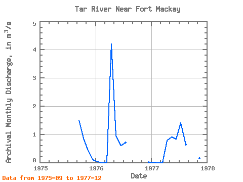
| Year | Jan | Feb | Mar | Apr | May | Jun | Jul | Aug | Sep | Oct | Nov | Dec | Annual | 1975 | 1.49 | 0.85 | 0.41 | 0.09 | 1976 | 0.02 | 0.00 | 0.01 | 4.21 | 0.94 | 0.61 | 0.71 | 0.01 | 1977 | 0.00 | 0.00 | 0.00 | 0.77 | 0.90 | 0.82 | 1.40 | 0.63 | 0.53 | 0.66 | 0.15 | 0.05 | 0.49 |
|---|
 Return to R-Arctic Net Home Page