|
|
|||||||||||||||||
| Point ID: 714 | Downloads | Plots | Site Data | Code: 07DA015 |
|
|
|||||||||||||||||
| Download | |
|---|---|
| Site Descriptor Information | Site Time Series Data |
| Link to all available data | |
|
|
| View: | Statistics | Time Series |
| Units: | m3/s |
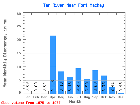
| Statistic | Jan | Feb | Mar | Apr | May | Jun | Jul | Aug | Sep | Oct | Nov | Dec | Annual |
|---|---|---|---|---|---|---|---|---|---|---|---|---|---|
| Mean | 0.09 | 0.00 | 0.04 | 21.45 | 8.17 | 6.16 | 9.39 | 5.59 | 8.69 | 6.75 | 2.41 | 0.43 | 51.71 |
| Standard Deviation | 0.10 | 0.00 | 0.06 | 20.93 | 0.22 | 1.33 | 4.33 | 5.85 | 1.20 | 1.62 | 0.37 | ||
| Min | 0.02 | 0.00 | 0.00 | 6.66 | 8.02 | 5.22 | 6.33 | 5.59 | 4.55 | 5.91 | 1.27 | 0.05 | 51.71 |
| Max | 0.16 | 0.00 | 0.09 | 36.25 | 8.33 | 7.10 | 12.46 | 5.59 | 12.83 | 7.60 | 3.56 | 0.80 | 51.71 |
| Coefficient of Variation | 1.13 | 1.41 | 0.97 | 0.03 | 0.22 | 0.46 | 0.67 | 0.18 | 0.67 | 0.87 |
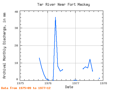
| Year | Jan | Feb | Mar | Apr | May | Jun | Jul | Aug | Sep | Oct | Nov | Dec | Annual | 1975 | 12.83 | 7.60 | 3.56 | 0.80 | 1976 | 0.16 | 0.00 | 0.09 | 36.25 | 8.33 | 5.22 | 6.33 | 0.05 | 1977 | 0.02 | 0.00 | 0.00 | 6.66 | 8.02 | 7.10 | 12.46 | 5.59 | 4.55 | 5.91 | 1.27 | 0.44 | 51.71 |
|---|
 Return to R-Arctic Net Home Page