|
|
|||||||||||||||||
| Point ID: 7121 | Downloads | Plots | Site Data | Code: 11580 |
|
|
|||||||||||||||||
| Download | |
|---|---|
| Site Descriptor Information | Site Time Series Data |
| Link to all available data | |
|
|
| View: | Statistics | Time Series |
| Units: | mm |
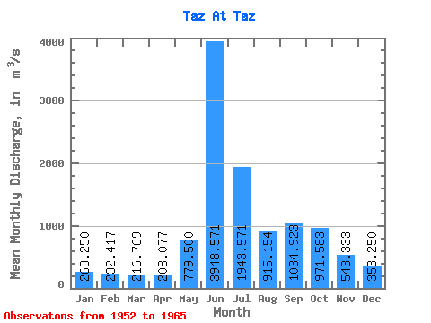
| Statistic | Jan | Feb | Mar | Apr | May | Jun | Jul | Aug | Sep | Oct | Nov | Dec | Annual |
|---|---|---|---|---|---|---|---|---|---|---|---|---|---|
| Mean | 268.25 | 232.42 | 216.77 | 208.08 | 779.50 | 3948.57 | 1943.57 | 915.15 | 1034.92 | 971.58 | 543.33 | 353.25 | 904.42 |
| Standard Deviation | 52.05 | 34.22 | 27.71 | 19.88 | 460.34 | 719.98 | 664.00 | 184.07 | 356.57 | 280.40 | 151.21 | 92.02 | 110.16 |
| Min | 194.00 | 175.00 | 165.00 | 176.00 | 255.00 | 2830.00 | 1180.00 | 570.00 | 541.00 | 575.00 | 313.00 | 237.00 | 727.00 |
| Max | 351.00 | 293.00 | 262.00 | 243.00 | 1850.00 | 5130.00 | 3550.00 | 1180.00 | 1800.00 | 1460.00 | 780.00 | 493.00 | 1085.75 |
| Coefficient of Variation | 0.19 | 0.15 | 0.13 | 0.10 | 0.59 | 0.18 | 0.34 | 0.20 | 0.34 | 0.29 | 0.28 | 0.26 | 0.12 |
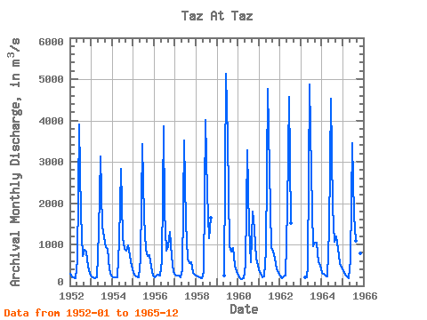
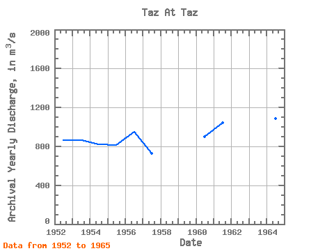
| Year | Jan | Feb | Mar | Apr | May | Jun | Jul | Aug | Sep | Oct | Nov | Dec | Annual | 1952 | 282.00 | 233.00 | 209.00 | 190.00 | 622.00 | 3900.00 | 1740.00 | 725.00 | 866.00 | 823.00 | 452.00 | 288.00 | 860.83 | 1953 | 220.00 | 195.00 | 188.00 | 209.00 | 1300.00 | 3120.00 | 1430.00 | 1180.00 | 943.00 | 887.00 | 398.00 | 255.00 | 860.42 | 1954 | 204.00 | 212.00 | 207.00 | 205.00 | 1090.00 | 2830.00 | 1180.00 | 896.00 | 851.00 | 978.00 | 724.00 | 493.00 | 822.50 | 1955 | 320.00 | 251.00 | 226.00 | 200.00 | 658.00 | 3440.00 | 1670.00 | 865.00 | 720.00 | 747.00 | 469.00 | 237.00 | 816.92 | 1956 | 194.00 | 256.00 | 262.00 | 238.00 | 619.00 | 3850.00 | 1800.00 | 858.00 | 950.00 | 1310.00 | 729.00 | 324.00 | 949.17 | 1957 | 267.00 | 248.00 | 244.00 | 208.00 | 368.00 | 3520.00 | 1510.00 | 658.00 | 541.00 | 575.00 | 313.00 | 272.00 | 727.00 | 1958 | 241.00 | 228.00 | 201.00 | 189.00 | 344.00 | 4020.00 | 2240.00 | 1140.00 | 1650.00 | 1959 | 255.00 | 5130.00 | 3550.00 | 962.00 | 836.00 | 906.00 | 480.00 | 346.00 | 1960 | 248.00 | 175.00 | 165.00 | 176.00 | 495.00 | 3280.00 | 1410.00 | 570.00 | 1800.00 | 1370.00 | 660.00 | 475.00 | 902.00 | 1961 | 333.00 | 238.00 | 211.00 | 227.00 | 835.00 | 4760.00 | 2800.00 | 932.00 | 837.00 | 655.00 | 396.00 | 312.00 | 1044.67 | 1962 | 244.00 | 192.00 | 234.00 | 243.00 | 1850.00 | 4570.00 | 1510.00 | 1963 | 195.00 | 210.00 | 493.00 | 4880.00 | 2740.00 | 951.00 | 1040.00 | 1050.00 | 575.00 | 477.00 | 1964 | 315.00 | 293.00 | 257.00 | 220.00 | 1370.00 | 4530.00 | 1910.00 | 1070.00 | 1190.00 | 898.00 | 544.00 | 432.00 | 1085.75 | 1965 | 351.00 | 268.00 | 219.00 | 190.00 | 614.00 | 3450.00 | 1720.00 | 1090.00 | 1230.00 | 1460.00 | 780.00 | 328.00 | 975.00 |
|---|
 Return to R-Arctic Net Home Page