|
|
|||||||||||||||||
| Point ID: 7006 | Downloads | Plots | Site Data | Code: 11293 |
|
|
|||||||||||||||||
| Download | |
|---|---|
| Site Descriptor Information | Site Time Series Data |
| Link to all available data | |
| View: | Time Series | All |
| Units: | m3/s |
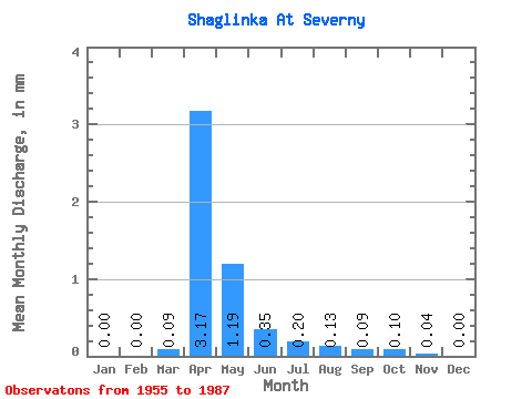
| Statistic | Jan | Feb | Mar | Apr | May | Jun | Jul | Aug | Sep | Oct | Nov | Dec | Annual |
|---|---|---|---|---|---|---|---|---|---|---|---|---|---|
| Mean | 0.00 | 0.00 | 0.06 | 1.91 | 0.72 | 0.21 | 0.12 | 0.08 | 0.06 | 0.06 | 0.02 | 0.00 | |
| Standard Deviation | 0.00 | 0.00 | 0.12 | 2.87 | 1.07 | 0.22 | 0.11 | 0.07 | 0.07 | 0.07 | 0.03 | 0.00 | |
| Min | 0.00 | 0.00 | 0.00 | 0.10 | 0.01 | 0.01 | 0.01 | 0.01 | 0.00 | 0.00 | 0.00 | 0.00 | |
| Max | 0.00 | 0.00 | 0.44 | 11.35 | 5.54 | 0.91 | 0.39 | 0.32 | 0.33 | 0.26 | 0.10 | 0.01 | |
| Coefficient of Variation | 2.18 | 1.50 | 1.50 | 1.04 | 0.88 | 0.99 | 1.27 | 1.09 | 1.08 | 1.60 |
 Return to R-Arctic Net Home Page