|
|
|||||||||||||||||
| Point ID: 7006 | Downloads | Plots | Site Data | Code: 11293 |
|
|
|||||||||||||||||
| Download | |
|---|---|
| Site Descriptor Information | Site Time Series Data |
| Link to all available data | |
| View: | Time Series | All |
| Units: | mm |
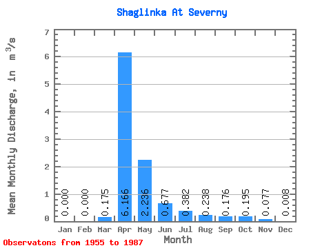
| Statistic | Jan | Feb | Mar | Apr | May | Jun | Jul | Aug | Sep | Oct | Nov | Dec | Annual |
|---|---|---|---|---|---|---|---|---|---|---|---|---|---|
| Mean | 0.00 | 0.00 | 0.17 | 6.17 | 2.24 | 0.68 | 0.38 | 0.24 | 0.18 | 0.20 | 0.08 | 0.01 | |
| Standard Deviation | 0.00 | 0.00 | 0.38 | 9.24 | 3.35 | 0.70 | 0.34 | 0.23 | 0.22 | 0.21 | 0.08 | 0.01 | |
| Min | 0.00 | 0.00 | 0.00 | 0.32 | 0.05 | 0.04 | 0.04 | 0.02 | 0.01 | 0.01 | 0.00 | 0.00 | |
| Max | 0.00 | 0.00 | 1.36 | 36.60 | 17.30 | 2.94 | 1.23 | 0.99 | 1.05 | 0.82 | 0.33 | 0.03 | |
| Coefficient of Variation | 2.18 | 1.50 | 1.50 | 1.04 | 0.88 | 0.99 | 1.27 | 1.09 | 1.08 | 1.60 |
 Return to R-Arctic Net Home Page