|
|
|||||||||||||||||
| Point ID: 6986 | Downloads | Plots | Site Data | Code: 11196 |
|
|
|||||||||||||||||
| Download | |
|---|---|
| Site Descriptor Information | Site Time Series Data |
| Link to all available data | |
| View: | Time Series | All |
| Units: | m3/s |
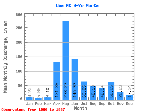
| Statistic | Jan | Feb | Mar | Apr | May | Jun | Jul | Aug | Sep | Oct | Nov | Dec | Annual |
|---|---|---|---|---|---|---|---|---|---|---|---|---|---|
| Mean | 8.92 | 5.90 | 9.10 | 131.35 | 273.23 | 140.97 | 63.84 | 48.12 | 42.54 | 62.04 | 28.83 | 17.34 | 809.63 |
| Standard Deviation | 2.96 | 2.34 | 7.75 | 40.40 | 85.39 | 70.41 | 34.42 | 26.82 | 30.95 | 35.91 | 11.20 | 10.63 | 193.66 |
| Min | 3.80 | 1.56 | 1.87 | 51.67 | 99.94 | 37.78 | 23.63 | 15.37 | 12.25 | 20.48 | 15.67 | 4.99 | 492.05 |
| Max | 16.28 | 11.20 | 40.61 | 199.91 | 488.34 | 281.22 | 156.83 | 116.75 | 166.87 | 167.16 | 55.91 | 57.24 | 1273.52 |
| Coefficient of Variation | 0.33 | 0.40 | 0.85 | 0.31 | 0.31 | 0.50 | 0.54 | 0.56 | 0.73 | 0.58 | 0.39 | 0.61 | 0.24 |
 Return to R-Arctic Net Home Page