|
|
|||||||||||||||||
| Point ID: 6986 | Downloads | Plots | Site Data | Code: 11196 |
|
|
|||||||||||||||||
| Download | |
|---|---|
| Site Descriptor Information | Site Time Series Data |
| Link to all available data | |

|
|
| View: | Statistics | Time Series |
| Units: | m3/s |
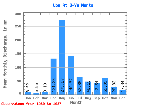
| Statistic | Jan | Feb | Mar | Apr | May | Jun | Jul | Aug | Sep | Oct | Nov | Dec | Annual |
|---|---|---|---|---|---|---|---|---|---|---|---|---|---|
| Mean | 8.92 | 5.90 | 9.10 | 131.35 | 273.23 | 140.97 | 63.84 | 48.12 | 42.54 | 62.04 | 28.83 | 17.34 | 809.63 |
| Standard Deviation | 2.96 | 2.34 | 7.75 | 40.40 | 85.39 | 70.41 | 34.42 | 26.82 | 30.95 | 35.91 | 11.20 | 10.63 | 193.66 |
| Min | 3.80 | 1.56 | 1.87 | 51.67 | 99.94 | 37.78 | 23.63 | 15.37 | 12.25 | 20.48 | 15.67 | 4.99 | 492.05 |
| Max | 16.28 | 11.20 | 40.61 | 199.91 | 488.34 | 281.22 | 156.83 | 116.75 | 166.87 | 167.16 | 55.91 | 57.24 | 1273.52 |
| Coefficient of Variation | 0.33 | 0.40 | 0.85 | 0.31 | 0.31 | 0.50 | 0.54 | 0.56 | 0.73 | 0.58 | 0.39 | 0.61 | 0.24 |
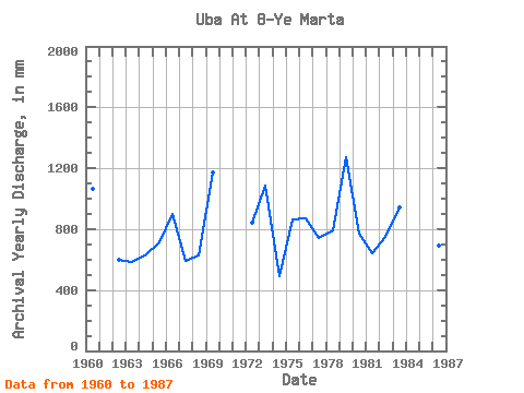
| Year | Jan | Feb | Mar | Apr | May | Jun | Jul | Aug | Sep | Oct | Nov | Dec | Annual | 1960 | 5.57 | 3.84 | 2.52 | 130.11 | 236.29 | 281.22 | 131.62 | 116.75 | 57.60 | 48.13 | 34.73 | 16.56 | 1062.64 | 1961 | 236.29 | 103.85 | 92.24 | 84.37 | 81.32 | 56.01 | 32.36 | 18.55 | 1962 | 12.78 | 6.79 | 24.16 | 145.69 | 204.79 | 66.75 | 23.63 | 15.37 | 12.25 | 43.93 | 16.45 | 27.66 | 597.99 | 1963 | 12.41 | 4.61 | 9.29 | 51.67 | 201.29 | 126.21 | 33.43 | 27.48 | 24.73 | 51.28 | 36.93 | 11.04 | 588.05 | 1964 | 6.81 | 3.68 | 5.88 | 100.12 | 250.30 | 130.11 | 40.78 | 30.63 | 20.50 | 20.65 | 15.67 | 7.18 | 630.01 | 1965 | 6.63 | 6.49 | 9.50 | 84.71 | 227.54 | 49.47 | 32.21 | 82.09 | 80.30 | 91.72 | 35.07 | 10.50 | 712.15 | 1966 | 12.46 | 10.65 | 7.46 | 103.17 | 311.56 | 276.14 | 85.42 | 34.48 | 19.82 | 20.48 | 15.86 | 7.77 | 903.59 | 1967 | 3.80 | 2.02 | 9.03 | 146.88 | 99.94 | 42.69 | 103.44 | 79.29 | 41.67 | 45.51 | 17.62 | 4.99 | 594.50 | 1968 | 5.27 | 5.82 | 40.61 | 137.73 | 224.04 | 37.78 | 49.18 | 19.78 | 41.67 | 43.93 | 17.45 | 10.48 | 630.60 | 1969 | 9.10 | 5.49 | 3.69 | 154.67 | 488.34 | 211.76 | 56.54 | 31.68 | 60.65 | 96.44 | 42.69 | 14.32 | 1170.14 | 1970 | 7.05 | 4.61 | 3.78 | 198.21 | 334.31 | 177.88 | 55.66 | 66.69 | 166.87 | 72.99 | 1971 | 199.91 | 362.32 | 177.88 | 70.19 | 59.16 | 28.63 | 22.23 | 25.41 | 15.60 | 1972 | 5.04 | 1.56 | 1.87 | 147.90 | 309.81 | 136.04 | 94.34 | 31.86 | 45.57 | 31.51 | 26.26 | 12.53 | 840.89 | 1973 | 7.88 | 5.21 | 7.37 | 186.35 | 364.07 | 188.05 | 113.07 | 79.99 | 43.03 | 61.26 | 20.84 | 15.68 | 1087.99 | 1974 | 6.77 | 3.84 | 3.20 | 142.47 | 144.05 | 52.69 | 24.86 | 20.48 | 28.29 | 28.70 | 24.23 | 12.85 | 492.05 | 1975 | 8.87 | 3.70 | 4.57 | 111.47 | 280.05 | 242.26 | 46.56 | 29.41 | 29.48 | 68.44 | 29.99 | 12.50 | 865.56 | 1976 | 10.27 | 6.09 | 7.75 | 129.09 | 250.30 | 74.37 | 80.34 | 45.33 | 49.98 | 167.16 | 35.75 | 18.55 | 869.31 | 1977 | 6.42 | 7.05 | 7.86 | 132.82 | 246.80 | 77.93 | 37.63 | 70.54 | 23.21 | 98.37 | 19.99 | 20.13 | 744.27 | 1978 | 16.28 | 9.44 | 10.03 | 161.28 | 173.98 | 167.55 | 37.81 | 54.09 | 26.60 | 55.48 | 42.86 | 35.53 | 790.63 | 1979 | 12.94 | 11.20 | 10.26 | 125.87 | 435.83 | 194.82 | 156.83 | 64.24 | 39.81 | 116.92 | 55.91 | 57.24 | 1273.52 | 1980 | 10.40 | 6.20 | 6.07 | 134.85 | 199.54 | 204.99 | 81.22 | 46.73 | 22.02 | 21.00 | 23.72 | 15.60 | 771.66 | 1981 | 9.22 | 7.00 | 9.01 | 182.97 | 238.04 | 65.90 | 30.98 | 22.23 | 20.50 | 25.20 | 20.33 | 9.77 | 639.78 | 1982 | 6.72 | 3.40 | 3.34 | 189.74 | 220.54 | 68.78 | 25.73 | 21.70 | 22.36 | 121.65 | 35.24 | 32.56 | 748.91 | 1983 | 10.47 | 6.76 | 10.66 | 83.52 | 379.82 | 196.52 | 47.08 | 28.53 | 54.72 | 55.84 | 54.89 | 19.60 | 944.75 | 1984 | 11.52 | 6.57 | 9.52 | 77.93 | 295.81 | 148.57 | 81.39 | 86.64 | 23.38 | 57.59 | 22.36 | 14.89 | 830.68 | 1985 | 9.66 | 7.11 | 11.06 | 129.43 | 299.31 | 179.58 | 54.61 | 51.81 | 29.82 | 78.77 | 26.09 | 16.75 | 890.54 | 1986 | 9.08 | 8.26 | 10.62 | 63.70 | 316.81 | 145.35 | 30.63 | 19.43 | 22.02 | 37.81 | 17.45 | 11.88 | 689.52 | 1987 | 8.58 | 5.88 | 7.46 | 94.19 | 318.56 | 122.15 | 70.19 | 26.61 | 74.20 | 98.19 | 32.19 | 17.40 | 870.98 |
|---|
 Return to R-Arctic Net Home Page