|
|
|||||||||||||||||
| Point ID: 6927 | Downloads | Plots | Site Data | Code: 10592 |
|
|
|||||||||||||||||
| Download | |
|---|---|
| Site Descriptor Information | Site Time Series Data |
| Link to all available data | |
| View: | Time Series | All |
| Units: | m3/s |
| Statistic | Jan | Feb | Mar | Apr | May | Jun | Jul | Aug | Sep | Oct | Nov | Dec | Annual |
|---|---|---|---|---|---|---|---|---|---|---|---|---|---|
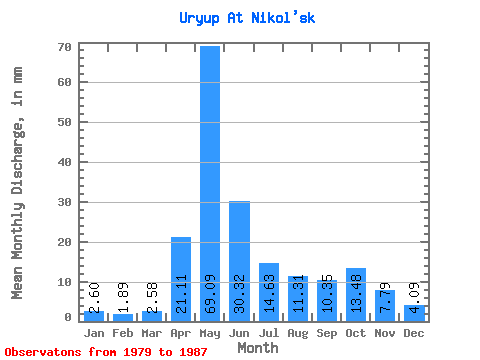
| Mean | 2.60 | 1.91 | 2.58 | 21.11 | 69.08 | 30.32 | 14.63 | 11.30 | 10.35 | 13.48 | 7.79 | 4.08 | 188.29 |
| Standard Deviation | 0.68 | 0.70 | 0.62 | 10.50 | 19.31 | 16.32 | 4.37 | 3.78 | 4.45 | 5.42 | 3.35 | 1.15 | 42.98 |
| Min | 1.40 | 0.82 | 1.99 | 10.10 | 43.13 | 10.62 | 7.26 | 7.58 | 6.61 | 7.58 | 3.93 | 2.24 | 129.82 |
| Max | 3.69 | 3.19 | 3.84 | 43.56 | 93.03 | 64.02 | 21.99 | 18.71 | 20.51 | 23.61 | 13.59 | 6.29 | 282.60 |
| Coefficient of Variation | 0.26 | 0.37 | 0.24 | 0.50 | 0.28 | 0.54 | 0.30 | 0.33 | 0.43 | 0.40 | 0.43 | 0.28 | 0.23 |
 Return to R-Arctic Net Home Page