|
|
|||||||||||||||||
| Point ID: 6927 | Downloads | Plots | Site Data | Code: 10592 |
|
|
|||||||||||||||||
| Download | |
|---|---|
| Site Descriptor Information | Site Time Series Data |
| Link to all available data | |
| View: | Time Series | All |
| Units: | mm |
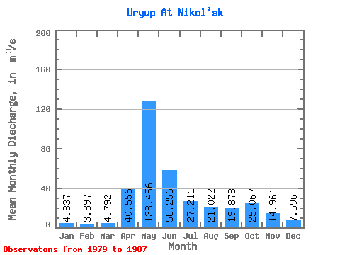
| Statistic | Jan | Feb | Mar | Apr | May | Jun | Jul | Aug | Sep | Oct | Nov | Dec | Annual |
|---|---|---|---|---|---|---|---|---|---|---|---|---|---|
| Mean | 4.84 | 3.90 | 4.79 | 40.56 | 128.46 | 58.26 | 27.21 | 21.02 | 19.88 | 25.07 | 14.96 | 7.60 | 29.71 |
| Standard Deviation | 1.27 | 1.43 | 1.16 | 20.18 | 35.92 | 31.35 | 8.12 | 7.03 | 8.55 | 10.07 | 6.44 | 2.13 | 6.78 |
| Min | 2.60 | 1.68 | 3.70 | 19.40 | 80.20 | 20.40 | 13.50 | 14.10 | 12.70 | 14.10 | 7.55 | 4.17 | 20.48 |
| Max | 6.86 | 6.51 | 7.15 | 83.70 | 173.00 | 123.00 | 40.90 | 34.80 | 39.40 | 43.90 | 26.10 | 11.70 | 44.59 |
| Coefficient of Variation | 0.26 | 0.37 | 0.24 | 0.50 | 0.28 | 0.54 | 0.30 | 0.33 | 0.43 | 0.40 | 0.43 | 0.28 | 0.23 |
 Return to R-Arctic Net Home Page