|
|
|||||||||||||||||
| Point ID: 6919 | Downloads | Plots | Site Data | Code: 10583 |
|
|
|||||||||||||||||
| Download | |
|---|---|
| Site Descriptor Information | Site Time Series Data |
| Link to all available data | |
| View: | Time Series | All |
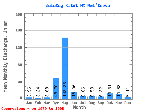
| Units: | m3/s |
| Statistic | Jan | Feb | Mar | Apr | May | Jun | Jul | Aug | Sep | Oct | Nov | Dec | Annual |
|---|---|---|---|---|---|---|---|---|---|---|---|---|---|
| Mean | 3.96 | 3.27 | 3.69 | 49.70 | 143.20 | 16.06 | 6.66 | 6.53 | 6.32 | 13.31 | 10.88 | 5.11 | 266.88 |
| Standard Deviation | 1.16 | 1.10 | 1.17 | 27.70 | 64.56 | 8.05 | 2.04 | 2.95 | 2.96 | 7.22 | 6.08 | 1.30 | 54.56 |
| Min | 1.93 | 1.56 | 1.83 | 11.62 | 34.91 | 6.20 | 3.69 | 3.03 | 2.68 | 4.85 | 2.94 | 2.53 | 159.81 |
| Max | 6.60 | 6.00 | 5.86 | 107.25 | 234.56 | 36.65 | 11.17 | 13.30 | 11.98 | 27.06 | 24.76 | 7.30 | 349.86 |
| Coefficient of Variation | 0.29 | 0.34 | 0.32 | 0.56 | 0.45 | 0.50 | 0.31 | 0.45 | 0.47 | 0.54 | 0.56 | 0.25 | 0.20 |
 Return to R-Arctic Net Home Page