|
|
|||||||||||||||||
| Point ID: 6919 | Downloads | Plots | Site Data | Code: 10583 |
|
|
|||||||||||||||||
| Download | |
|---|---|
| Site Descriptor Information | Site Time Series Data |
| Link to all available data | |
| View: | Time Series | All |
| Units: | mm |
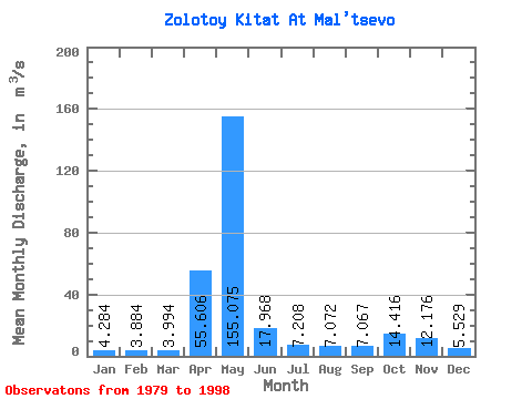
| Statistic | Jan | Feb | Mar | Apr | May | Jun | Jul | Aug | Sep | Oct | Nov | Dec | Annual |
|---|---|---|---|---|---|---|---|---|---|---|---|---|---|
| Mean | 4.28 | 3.88 | 3.99 | 55.61 | 155.07 | 17.97 | 7.21 | 7.07 | 7.07 | 14.42 | 12.18 | 5.53 | 24.52 |
| Standard Deviation | 1.25 | 1.31 | 1.26 | 31.00 | 69.91 | 9.00 | 2.21 | 3.20 | 3.31 | 7.82 | 6.80 | 1.40 | 5.01 |
| Min | 2.09 | 1.86 | 1.98 | 13.00 | 37.80 | 6.94 | 3.99 | 3.28 | 3.00 | 5.25 | 3.29 | 2.74 | 14.69 |
| Max | 7.15 | 7.13 | 6.35 | 120.00 | 254.00 | 41.00 | 12.10 | 14.40 | 13.40 | 29.30 | 27.70 | 7.91 | 32.15 |
| Coefficient of Variation | 0.29 | 0.34 | 0.32 | 0.56 | 0.45 | 0.50 | 0.31 | 0.45 | 0.47 | 0.54 | 0.56 | 0.25 | 0.20 |
 Return to R-Arctic Net Home Page